Welcome to David and Janet Ribbans blog

We live in Adelaide, South Australia and enjoy travel in the Australian outback in our Oka 4WD motorhome, hence the blog title.


To quickly locate any of our more than 80 travel and technical articles, use the drop down menus below or scroll down the lists in the right hand sidebar. But please read the disclaimer first, we've tried to be accurate and current but things can change...
You can also visit the official Oka 4WD website here.

Pandora Web Archive


We're now honoured to have our blogs archived
on the National Library of Australia's Pandora Web Archive.
Bookmark this link to the archived version in case anything ever goes wrong with Google, or I accidentally hit "Delete All" in a fit of pique. The drop down menus above might not work in the archived version but everything else should...

Friday 19 December 2008

History of our Oka Travels

This has now been moved to the right hand sidebar, so it's nearer to hand.

Sunday 14 December 2008

2008 In Review

To all our family and friends.
Once again we've had a full, exciting and occasionally sad year.
In January we had our customary Australia Day BBQ on 26th January. It was hot of course, being mid summer, but we had a garden full of people and we sat out under the stars until very late (ie about 9.30 at our age).

In February we fitted solar panels to our Oka, ready for our next outback trek.

In March we had a severe wind gust which blew our new glass topped outdoor table across the patio and smashed it into a zillion pieces. Fortunately the insurance company paid for a new one.

In April, Scott bought a house about 10 kms away so we were busy fitting stuff to it: a new mail box, replacing window locks, extending his verandah, wiring up his workshop, all the things we didn't have the time for but what parents are expected to do as a matter of course.

In May we overhauled the suspension on our Oka. Fitting new suspension bushes means lifting a 6 tonne vehicle safely to remove the heavy springs and is NOT EASY.

In April we were invited to a former colleague's 60th birthday party in Moonta, a coastal town about 100 kms up the gulf. It was a surprise event which Mike knew almost nothing about and went off very well. His wife Jill arranged everything including renting 2 houses for the weekend for guest to stay at. We had a ball, but also a sore head the next day.

We also had a day trip to Sydney in April courtesy of my QANTAS Frequent Flyer points. We rode the train from the airport across the harbour bridge and did a tour of the Opera House. We hadn't realised it was so complex a structure inside. There were some musical performers rehearsing and the acoustics were quite amazing.

In May we went to a 4WD Weekend arranged by our HF Radio Club in Quorn in the Flinders Ranges. This is a magic part of the country and only about 400 kms north of here. Local land owners have opened up their properties and access tracks to visitors. We did 2 very tough tracks which climbed and wound tortuously through the hills for 20 kms or so. We nearly rolled the Oka over on a few hair rising turns but escaped intact to fight another day.

Endless talk of our experiences around the BBQs took up each evening.

In June we left for another trek across Australia. We met up with some friends in Coober Pedy (1000kms north of here) and drove across the Great Victoria Desert on the Anne Beadell Highway, which is as far removed from being a "highway" as it's possible to imagine, it's just 2 wheel tracks across endless sand dunes and remote, but beautiful desert country. It took us 12 days to cover the 1500 kms and there was only one place to buy fuel and only 3 places where rain water was available. Lucky we are well prepared and fully self sufficient.

In July, continuing our trek, we turned north and trundled across yet more desert tracks to Alice Springs and had a good couple of days at Ormiston Gorge with Tim and Brenda, fellow Oka owners from Byron Bay in NSW.

It's getting warm now as we head further north into the tropics and meet up with Charles and Fred, our friends from the UK who come out here for a few months each year to see a bit more of the country. We waited in Tennant Creek for their triumphant arrival but then I got a text message to say they had already triumphantly arrived some time earlier, and were waiting for us at the caravan park.

We spent the rest of July and part of August travelling with them up to Darwin which is a delightful city but where it was very hot and sticky.

While in Darwin we received a very sad message to say that the son of a very good friend had died after a car accident. We were devastated of course but what can you say or do when you're 3000 kms away? We had known George all his life (26 years) and while we can still remember his Christening, we couldn't attend his funeral, and that left us a bit shell shocked for a few days. 

But then Charles and Fred had to move on to catch flights home and we parted company until next year and we carried on our trek. That took us across the Northern Territory, where had some scary moments with crocodiles, towards the Gulf of Capenteria and to Mount Isa, and from there we headed south across outback Queensland arriving home 2000 kms later at the end of September.

We'd been away for 3 1/2 months, covered 14,000 kms, ticked off several other remote locations and revisited some of our favourites.

We'd had yet another great trek, but the garden had gone completely feral as you can imagine. So October and November seems to have been taken up with garden and house maintenance.

Recently I saw the design of a simple slide copier in an electronics magazine so I was fired up with a desire to relive our experiences on our overland trip from the UK to Australia in 1974/5. So I built it and copied all our best slides from the era into digital format. You can see these at http://picasaweb.google.com/jcribbans.

It is kind of scary to see just how young and slim we were then. I made a resolution to go on an immediate hunger strike, right after breakfast.

Today, ironically in the midst of both the global economic crisis and pre-Christmas spending rush, we are both fit and well and looking forward to our next years adventures, whatever they may be.

For some reason we have been thinking and talking of our long distance friends and relatives more this year than in previous years. Maybe the global crisis has made the world a smaller place. Certainly we are all in the same boat this year and, thinking positively, it can only get better from here?

Best wishes to you all for a safe, happy and rewarding Christmas and New Year.

David and Janet

Monday 8 December 2008

Gary Highway

Because there wasn't one, I wrote a Wikipedia entry for the Gary Highway, which you can see at this Wiki site.

It contains more geographic info than this blog entry and there's also a useful map at the Wild Discovery Guides site.

We came down the top 700 km section of the CSR to Well 33 and Kunawaritji in September 2007, and then 400 kms down the Gary Highway to Everard Junction.

It's then still a further 400 kms down the Gunbarrel/Heather Highways and Great Central Road to the Warburton Community.

Although the Gary Highway almost dead straight (except for a section at the northern end where it winds around some sanddunes), and plenty corrugated, there are some interesting diversions along the way.

1) Veevers Meteorite Crater, 16 kms off the track.


These are the original hand written notes in the visitors book at Veevers Meteorite Crater by Eugene Shoemaker, who confirmed Veevers as a meterorite impact crater.
Eugene Shoemaker was a world renowned meteorite expert from the USA who searched the world for impact craters, and documented most of those in Australia. His biography can be found here and a Wikipedia entry here.
He became a good friend of Len Beadell and visited Australia often. The Shoemakers named an asteroid, discovered by Caroline Shoemaker in 1980, after Len Beadell. It is now known as 3161 Beadell (1980 TB5) and is 12.5 km in diameter.
Len and his family visited the Shoemakers in the US during 1986, and sadly, it was on the Shoemakers next trip to Australia, on 18th July 1997, that Eugene was tragically killed in a car crash in the Tanami Desert. Subsequently, some of his ashes were carried to the Moon by the Lunar Prospector space probe, and to date, he is the only person to have been buried on the moon. The background to this tribute can be seen here.

This is a video of Veevers Meteorite Crater in 2007.


Veevers Meteorite Crater
Signs by the original finders...
Photobucket


2) Tropic of Capricorn


Markers are located at several places around the latitude of the actual Tropic, since it's position has been recomputed and changed as the earth's tilt varies.
The earth's axial tilt varies between 22.1° and 24.5° and is currently 23° 26’ 21.448”. In 1900, it was 23° 27’ 8.26”. See this Wikipedia entry for more details than you'll ever need.


3) Windy Corner, the eastern end of the Talawana track,


Len Beadell spent several days stuck here in a sand storm, hence the name.
4) McDougall Knoll, a good lunch spot overlooking the Gibson Desert.


Look for the tin can (visitors book) lodged in the cairn.


5) Eagle Highway Junction, which looks very overgrown.


6) Gibson Desert Nature Park, which includes:


7) McPhersons Pillar and Milgan Rockhole, both 30 kms off the track to the east,


McPhersons Pillar


The view from the top of McPhersons Pillar. A lonely spot in a big desert. Look for a glass jar (visitors book) hanging from a bush. You can camp in this track loop.


Mulgan Rockhole, dry in 2007
8) Charlies Knob,
A useful lunchspot.


9) Everard Junction with the Gunbarrel Highway at the southern end of the Gary Highway.


It doesn't look it, but it was a stinking hot 40º that day.


From there the track east leads to Mount Beadell, then down the Heather Highway to the Great Central Road.

Mount Beadell. Well worth the climb and there's a good campsite at the base.


One of Len Beadell's few remaining original signs, still there, no doubt, due to the 23 nails holding it to the tree.


There are no buildings or facilities of any kind along the Gary Highway (or Gunbarrel/Heather Highway sections either) and it is very remote from any help. In the 5 days and 800 kms from Kunawaritji to the Great Central Road we saw not a single vehicle or person.


No permits are required for the Gary Highway itself (or the CSR, unless you deviate off it) but they are needed for the connecting roads and tracks (Great Central Road, Gun Barrel Highway and Gary Junction Road). Permits are easily obtainable on-line.

Tuesday 2 December 2008

Giles Meteorology Station

Giles Met Office was developed by Len Beadell in the 1950's to provide support to the Woomera Rocket Range.
We visited Giles Met Office on our previous trip in 2007 but didn't get to see around the facility due to "computer problems". This time we were more lucky and in fact we were given a tour all by ourselves by "David" (no relation).
It was quite fascinating. All over Australia at dozens of weather stations, weather balloons are released 3 times a day, at exactly the same time everywhere, to provide a national snapshot of the weather situation.
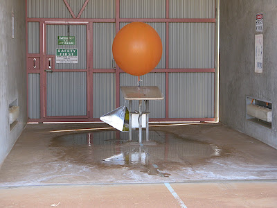
It was hot but "David" still had to don protective clothing while filling the balloons with hydrogen, which is a risky and dangerous process. The entire building and gas filling area is sprayed with water during the inflation process to reduce the risk of static charges igniting the hydrogen.
IMG_8511.JPG-2008-12-2-00-10-2008-12-2-00-10.jpg
After release, the height, drift direction and speed of the balloon is tracked by radar and displayed on a computer screen.
IMG_8514.JPG-2008-12-2-00-10-2008-12-2-00-10.jpg
"David" took us inside and showed us all the equipment in operation.
IMG_8522-2008-12-2-00-10-2008-12-2-00-10.jpg
On the left is the wind speed profile vs height as the balloon ascends, and on the right is wind direction vs height. It was interesting how much the wind direction varies with height.
These are computed from the radar track returned from a passive reflector below the balloon.
Active electronics packages (radiosonde equipments) are only used occasionally, since their weight requires a much larger balloon and can't ascend so far, but they can then acquire air temperature, air pressure and humidity data as well, and transmit this information to the ground station.
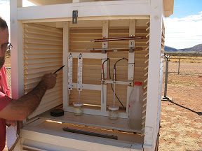
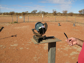
The base staff also collect other ground weather data, rain, temperature, humidity, sunlight etc, from electronics sensors, but all data is also corroborated by old fashioned mechanical devices as well. They don't fully trust technology yet.
IMG_8520.JPG-2008-12-2-00-10-2008-12-2-00-10.jpg
IMG_8521.JPG-2008-12-2-00-10-2008-12-2-00-10.jpg
Apparently, the 4 staff at Giles rotate on a 6 monthly basis and I suggested that was good since they would get a remote area tax concession. "David" went sour at that point and said "to get the tax concession, you have to live remotely for 183 days in a year, and a 6 month secondment is only 180 days". End of tour.
Although Giles is well inside Western Australia, it operates on Central Standard Time (Adelaide time), presumably because it was established as a branch of the Weapons Research Establishment (now DSTO) in SA in 1956 and the staff are still assigned there from the Adelaide BOM. More info on the Giles Met office can be seen here.
Giles was established in the 1950's by Len Beadell as part of the Woomera rocket range instrumentation system and much of his memorabilia still remains there, including his grader which built 6,000 kms of outback tracks and a collection of some of his original marker plaques. The originals have mostly been replaced by replicas to reduce theft and vandalism.
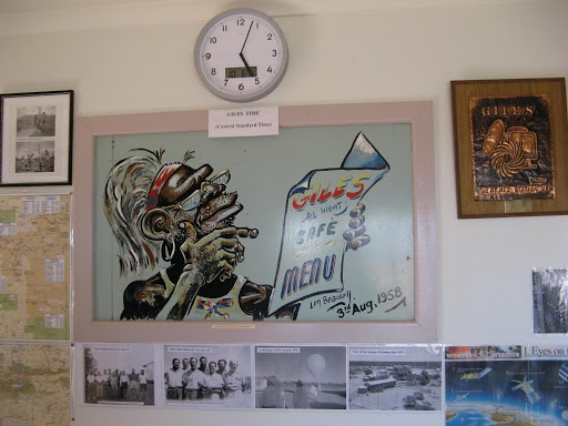
IMG_1030-2008-12-2-00-10-2008-12-2-00-10.jpg IMG_8499.JPG-2008-12-2-00-10-2008-12-2-00-10.jpg
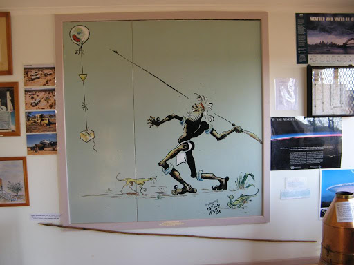
Some of Len Beadell's original artworks can still be seen in the visitor centre.
IMG_1039-2008-12-2-00-10-2008-12-2-00-10.jpg
IMG_1037-2008-12-2-00-10-2008-12-2-00-10.jpg
There are also the remains of a Blue Streak rocket which was fired from Woomera in 1964 but only discovered in 1980, 50 kms south east of Giles.
IMG_1021-2008-12-2-00-10-2008-12-2-00-10.jpg
IMG_1022-2008-12-2-00-10-2008-12-2-00-10.jpg

Monday 1 December 2008

Atomic Bomb Tests in the Great Victoria Desert, South Australia

In the western deserts of South Australia, 9 British atomic bomb tests were conducted during the 1950's. How Australia came to be mixed up in British atomic weapons testing program used to be on the Atomic Forum website. However that site is no longer valid so you should refer to the Wikipedia entry on the Totem bomb program. More useful information is available here.

PastedGraphic8-2008-12-1-15-06.png

Totem 1 Explosion. The diagonal stripes are the trails of rockets fired through the cloud to monitor radiation levels

Two bombs were detonated at Emu Field on the 15 and 27 October 1953, on the Anne Beadell Highway, 300kms west of Coober Pedy, and 7 more subsequently at Maralinga near the Trans-Australia railway.

Len Beadell built the roads and tracks to support this project, some of which are still accessible, although Maralinga access is still very restricted, and for good reason. See the findings of the Royal Commission.

You can visit the sites of the Emu Field bomb tests and it's quite an eerie experience standing on the very point where an atomic bomb was exploded. Not many people do that and survive!

The video and photo below of the Totem 1 explosion are from Department of Primary Industries and Energy. A lot more useful information can be found at Wikipedia entry on the Totem bomb program.

Totem  1 Explosion, the first atomic explosion on Australian mainland

Concrete obelisks now mark the Ground Zero points and a level of radiation still remains, but it is now at a low enough level to allow short duration visits, but not permanent habitation in the area.

PastedGraphic-2008-12-1-15-06.png

Where we stood, 55 years later

PastedGraphic1-2008-12-1-15-06.png

The obelisk at Ground Zero

The first 2 bombs, code-named Totem 1 and Totem 11 were 9.1 and 7.1 kilotons respectively, not big by super-power standards, but they made quite a mess of the ground.
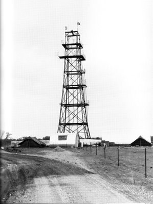
PastedGraphic4-2008-12-1-15-06.png

The original towers from which the bombs were suspended...
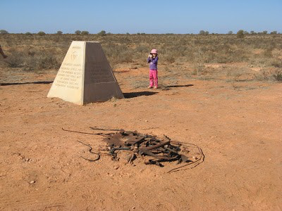
PastedGraphic5-2008-12-1-15-06.png

...and the remains of the towers

Of the 100ft towers they were mounted on, only a few buckled frames remain on the ground, and the surrounding desert is covered in glassy lumps of molten sand.

PastedGraphic2-2008-12-1-15-06.png

One of the 4 mounting pads of the 100 foot tower
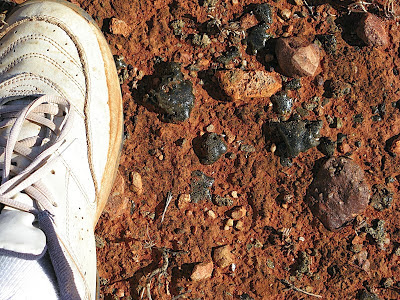
PastedGraphic3-2008-12-1-15-06.png

Molten desert sand after the explosion
PastedGraphic6-2008-12-1-15-06.png

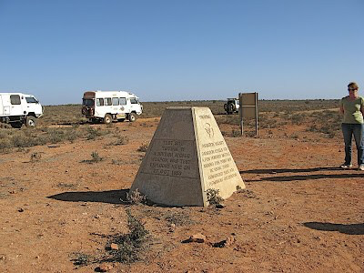
Totem 11 Obelisk, just 1 km from Totem 1

PastedGraphic7-2008-12-1-15-06.png


This is a display  from our moving map system showing the location of the bomb sites in the Great Victoria Desert in the west of South Australia


Lake Ballard Statues
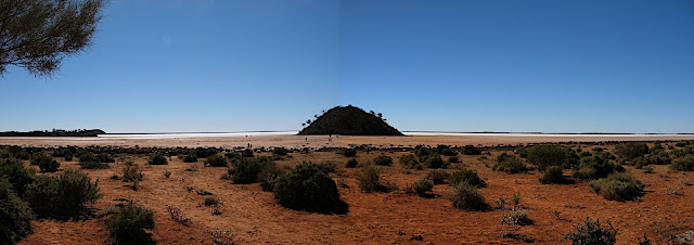
Lake Ballard, a salt lake near Menzies, 800 kms northeast of Perth, is the site for a strange art exhibit called "Inside Australia".


The statues are very spaced out, and far apart!


It comprises 51 abstract black steel figures scattered over 10 square kilometres of the lake, approximately 55km west from the town. The exhibition was commissioned from British artist, Antony Gormley, to mark the 50th anniversary celebrations of the Perth International Arts Festival in 2003. The 51 sculptures are supposedly derived from laser scans of the inhabitants of Menzies, although the likenesses are a bit difficult to comprehend.

Yes, I can just see the likeness.


The statues are several hundred meters apart and we only got around to about 12 of them. It's a bit tedious, sloshing around the soft surface of the lake in the hot sun, and after a while they all start looking the same.


We were not the only visitors to the salt lake, even Kangaroos apparently visit the statues. We wondered what motivated them to cross such a wide expanse of salt. Most of the statues are of women or girls, but a few are male. See what you think.


Tuesday 25 November 2008

Sandy Blight Junction Road

This road/track (it's called a road but is really a track) was built by Len Beadell in the 1960's but differs from his normal strategy of building roads "gunbarrel" straight. This one is very winding and "periphrastic" (even Janet had to look that one up, it means speech or writing that is tortuous, indirect or circumlocutory. I think it applies to the SBJ road too).


On the map it doesn't look very long, a tad over 200 kms as the emu flies, (from south to north, and presumably the same flying back the other way), linking the Great Central Road near Giles to the Gary Junction Road which runs west from the Tanami Track just north of Alice Springs. However, while it is quite scenic, the track at ground level was very winding, and at nearly 400 kms, much more tortuous than we were expecting.

Our first surprise was that Len Beadell's Sandy Blight Junction Road marker tree is actually 9 kms from the start of the current track, due to subsequent track realignment. Once located, the first 70 kms or so of the track are quite reasonable since it leads to an Aboriginal community at Tjukurla. Thereafter the road becomes a 2 wheel desert track which winds through hills and sanddune country for a further 300+ kms. It is alternately very rocky and rough, or deep corrugated sand. It's the sort of track for which a sports bra is highly recommended.

As we started the 2 wheel track section we were met by a couple of rally cars, then a few more, and finally lots of rally cars, 40 (yes forty, four-zero) cars, separated by about a km, all coming down the same 2 wheel tracks up which we were trying to navigate.
After pulling off the track for each of the first dozen or so, we gave up and stopped for lunch until they had all gone past us. They all had their CB's on full blast and we were well known to all of them by the time they had all slowed down to say "Hello" and pass us by.
They were apparently doing a Brisbane to Longreach charity rally, the long way round. How they navigated through the deep sand in their road cars is a mystery, although the last one was being towed.


The 400 kms took us 3 days and eventually I was quite looking forward to reaching Sandy Blight Junction, especially during the final 25 kms dead straight section which seemed to take forever.

Along the way, however, there are quite a few interesting points.

Bundabiddy Rockhole was found by Len Beadell in the Walter James Range, and we found it too, about 1 km off the track.
 
Being in the dry season, it was in a worst state than how Len Beadell described it. He went swimming in it while surveying the track and boasted how he'd been "swimming in the desert", but now it's slimy green and surrounded by animal droppings. A useful water supply, nonetheless, in an otherwise waterless desert.
About halfway along the track, at 124 miles, is a tree blazed by len Beadell with a Half Way marker, as if to give some hope to tired travellers that they were actually making progress.


Summit of the Sir Fredrick Range

A bit further along is a sign to a track to the summit of the Sir Fredrick Range, complete with dire warnings of VERY steep grades and GPS coordinates for the emergency (read "chickening out") turning round points. We chose to stay of flatter ground but we have heard of others having to make 15 point turns on a near vertical track to backtrack.


We camped soon after this and I turned off the track to find a suitable spot. I was about to turn around when something stopped me and we stayed where we were. When I got out to look around, I found a deep hole right behind where I was about to reverse. It gave me nightmares all night thinking about how I would have got the Oka out if I had dropped a wheel (and axle) into that hole. Janet placed a rusty oil drum in front of it to remind me NOT TO DO IT.
At 140 miles there is another Len Beadell marker, apparently for no other reason than it was 140 miles from Giles.


200 Mile Rock
At the 200 mile point (from the Great Central Road), Len Beadell located a large rock which is painted white to mark the 200 mile point. It's still there but as Len pointed out, it's relevance was rendered worthless with the introduction of metrication into Australia.
Just before the 200 mile rock, we took a shortcut across some sanddunes to avoid a 5 km trip to go around them. Well it might have been shorter in distance, but since we got stuck on one, it wasn't shorter in time. I had trouble getting over the sanddune with tyre presures set for rocky ground so we had to reverse off, drop the pressures even further and then try again, this time successfully. All good fun.
The Tropic of Capricorn?
As we crossed the Tropic of Capricorn, suddenly nothing happened, none of the usual signs were there. They were a few hundred meters up the track. Apparently, at some time in the past 50 years the location of the tropics has been re-computed which means all the old signs are now in the wrong place. We have found this on several outback tracks which cross the tropic.
Tietkens Tree
Towards the end of the track is another Len Beadell marker, this time the rediscovery of a long dead tree which was blazed in 1875 by William Harry Tietkens, an early explorer in WA and second in command to Giles in his expeditions. The tree is now dead and fallen over but the inscription has been preserved. Visit http://adbonline.anu.edu.au/biogs/A060295b.htm for a biography of Tietkens.
Don't Take Trailers on outback tracks
On the side of the track we found a recently abandoned trailer, still with all it's wheels, jerry cans and some food, still fresh. It was in pieces and only the axle is missing, presumably the reason for it's demise was bearing failure. It had a sticker on it from Yulara camp ground dated 9th July, only 5 days before we found it. It might have been left by the rally group we saw earlier, but we have found so many trailer wrecks or broken down trailers needing assistance we wish people would get the message: "Don't take trailers on outback tracks." They can't take the rough conditions, even so-called off-road trailers.


Track Ends
On our last day on the track we had to do some washing. We stopped for lunch in the middle of the track, since we had seen no one for 2 days and hung the washing out across the track to dry.
Five minutes after taking in the dry clothes, a 4WD from the Aboriginal community roared past, the first vehicle we'd seen since the Great Rally Car convoy. Just lucky I guess.
When we reached the end of this track at Sandy Blight Junction (after which the track was named) it was high fives all round for getting through it. It had been tougher than expected but we had made it. It was not surprising to see the road sign at this end grandly announcing "4 WHEEL DRIVE ONLY". There was no similar sign at the other end, only a rusty car bonnet on the side of the road near Tjukurlka with "4wd" scratched on it. And the 340 kms was a tad optimistic too, we did nearly 400 kms, and Docker River is a further 25 kms from the start of the track anyway. Len Beadell's marker at Sandy Blight Junction shows the distance to Giles as 252 miles, which is 405 kms.
But overall it was a good drive and well worth the effort. We had no hassles getting permits, we applied on-line and had them emailed back to us in a couple of days.
The graphic below shows our average speed profile on this track, around 50 kph on the first section, dropping to 25 on the sandy/rocky sections and then speeding up again as we approached the end.
Beadell Markers
There are more Len Beadell markers to the square meter on this track than we have seen on any other, 10 apparently, although we didn't count them all. Did he have time to kill, or spare aluminium plates to use up? It's not as though the track was easy to build, it would have been quite difficult compared with his normal straight and level tracks. And it wasn't likely to be a highly used track, his most frequented tracks are east-west.


But the intrigue continued. For some unaccountable reason, Len Beadell's party actually continued the track for a further 37 kms into uncharted desert areas for no apparent reason. The track actually stops in the middle of a huge area of sanddunes with no obvious destination in sight. The faint red line winding north on this map stops abruptly in a mess of sanddunes.
Why? Was he beaten by the difficulties presented by the sanddunes? Not likely, Len Beadell was never one to give in. Was he aiming for the Aboriginal community at Nyirripi, 85 kms to the north east, and thus close the loop to Yuendumu on the Tanami Track? 
On Len Beadell's original marker plaque (see below) which is now located at Giles, with a replica at Sandy Blight Junction, he shows a track north to Vaughan Springs, but with no distance marked, just a blank space then "M" for miles. Vaughan Springs is 50 kms north east of Nyirripi in the Treuer Range, so the theory that the Sandy Blight Junction Road was eventually intended to link up with the Tanami Track seems entirely plausible.
Like his other tracks, Beadell would put up plaques as the roads were built and then come back subsequently to mark actual distances on them after they were finished. This plaque was never completed.
But why was the track to Vaughan Springs not completed? Maybe he was getting beyond his main geographic area of activity and was called back to more pressing work?
One other school of thought is that the Gary Junction Road was originally going to be located further north, but was subsequently re-routed further south. Sandy Blight Junction would thus end up where it is now, south of the actual end of the track. That would leave the top end of the track unused, and explain the conundrum.