We've just come back from 3 weeks in New Zealand.
We didn't take our Oka with us (the excess baggage cost was beyond our budget) but we did hire a people mover and had a great tour of the North Island. (We'll need to return someday to do the South Island).

The Christchurch earthquake hit while on the northwest coast fortunately, but in a strange way we wish we had been in the south to help with the rescue effort, you just feel so impotent stuck in the north, looking on. The people generally were shattered. Chch (as they abbreviate it) is their second largest city (it ties with Wellington) and the effect on them would be similar to Melbourne being destroyed here.
The reason we went to NZ was to attend a niece's wedding on a beach north of Wellington. That went very well but will be of little interest to the Oka community at large. But with Oka's in mind, we did visit Okato, a small town on the west coast and the nearest we came mentally to an actual Oka. Pity they didn't actually use any.
Good things: Very scenic, high quality lifestyle, clean, economic, quirky and fun.
Not so good things: Cool and cloudy, extensive land clearance and logging, almost no native wildlife, daily earthquakes.
Janet's highlight: Cultural performance at the Maori Thermal Village in Rotorua.
My highlight: Tour of White Island, an active volcano 50 km off the north coast. You don't get to see that every day.
Summary: We'll be back for a longer tour, it was good.
If you are interested in what the NI was like for us (much good, some bad), click on Read more just below, otherwise use the links in the right sidebar to find our other articles.
Read more:
Overview
NZ is larger than we thought and extremely hilly, most houses seem to built on the steep sides of hills. Although it looks small on the map and is only one 30th the size of Australia, NZ is larger than the UK and 4 times the area of Tasmania.
Its coastline, at 15,000 km long, is around half the length of Australia's, due to the thousands of small bays and inlets. This makes most of the country extremely scenic, but it also means that roads are, in general, very winding and hilly, which slows driving and give the impression that distances are longer than they actually are.
Across the centre there are a few large flat farming areas and Wellington and Auckland have very good motorway systems which makes driving in and out quite simple. A Navman or similar is very useful for finding the best routes between centres as some of their towns have very long and unfamiliar place names.
Commerce
Right now, New Zealand makes for very economical traveling. The rising Aussie dollar and the prices of most commodities in NZ makes touring NZ reasonably inexpensive. Apart from petrol ($NZ2.00/l) most goods are at similar or lower prices than in Australia, but with a 1.3:1 exchange rate, the resulting price is about 2/3 the Aussie price for the same item.
Credit cards work fine but not our ATM cash cards. Maybe they need to be activated before traveling but we really thought we would have no problems in this regard in our nearest neighbour. We also heard that NZ cash cards don't work in OZ, which is also strange considering most banks are common to both countries. I must check this out.
Language Duffuculties
There are a few words which quickly become part of the vocabulary after arriving in NZ:
Earthquake. NZ is located on the edge of the Australasian tectonic plate and is very earthquake prone, as sadly evidenced by the tragic Christchurch quake. Reasonable earthquakes between 4 and 5 on the Richter scale are very common, on average 1 per day. They can be felt at this magnitude but seldom do any real damage. There was one in Wellington the day after we left. Most houses are timber framed to reduce their susceptibility to earthquake and everyone has an earthquake survival kit in their homes and cars. Although major quakes are rare, 1 or 2 per year, it's impossible to drive through the motorway tunnels around Wellington with giving a casual thought as to their strength in a quake.
This picture from the NZ Geonet website shows the extent of earthquake activity in NZ. It's hard to escape from them but it's interesting that Christchurch on the east coast of the South Island is not in a particularly susceptible area. Perhaps it is now.
Slup or Landslup. Due to the steepness of the hillsides and high rainfall, land slips are common place and all roads can be regularly affected by land slips. This has been made worse by the unfortunate mass clearing of much of the bushland for sheep and cattle grazing in the late 1800's which removed the binding effect of roots in the soil.
Quirky. All over NZ there are signs, sculptures, buildings and businesses that can only be described as quirky. This makes NZ fun as well as scenic. Their obsession with things extreme is a good example: including bungy jumping, jet boats, tubing over rapids, caving and white water rafting.
Volcano. There are at least 2 active volcanoes in the NI (White Island and Ruapehu) and dozens of dormant ones. We did a trip out to White Island, an active volcano on an island 50 km off the northern coast. It was a very strange feeling walking around a hissing, steaming, bubbling volcanic crater. It last erupted in 2000 which is not that long ago in geological terms, and we had to wear hard hats and gas masks. What we didn't know is that there had been 6.4 earthquake on White Island only last September 29th, more powerful than the Christchurch quake but presumably deeper.
Marae. A Maori meeting room or village hall. There is a very strong Maori culture present in NZ with Maori villages distributed across the country and Maori place names very common. The Maori language uses only 15 letters but they are able to generate extremely long and unpronounceable place names. Try Papakawhai (where we stayed in Wellington), Paraparaumu, Paekakariki, and for extreme size, Taumatawhakatangihangakoauauotamateaturipukakapikimaungahoronukupokaiwhenuakitanatahu, which is officially the longest place name in the world, in the north east of the North Island, but strangely they don't mark it on the map. We actually met a resident who could pronounce it.
And just to make things more interesting, "wh" in a word is pronounced "f".
Thermal. In a broad belt all across the North Island, there are thermal areas of bubbling mud pools, geysers, pools of boiling water, thermal baths and steam just issuing forth from green paddocks alongside quietly grazing cattle. They also produce a lot of geothermal electricity and heating. Some of these features can be seen freely, but most are now sadly in private hands (including White Island oddly, now who would want to own an active volcano?) and charge quite highly for tours and access. Despite this, they are well worth visiting for things you just don't see everyday.
Fush an Chups. Yes it's difficult to ignore the peculiarities of the Kiwi accent, but after a few days you do get used to it. Initially it makes you giggle a bit and then you get used to it and then, heavens above, you actually start talking like one. In an apparent swipe at the Aussies, you do actually get the words Fush and Chups written that way on the menu, and Fish and Chip shops are the predominant fast food outlet, far more common than the usual Chinese, Indian or even Maca type take aways.
My favourite Kiwi expression came from an episode of Go Girls: "Thus just guves me the shuts!"
Most houses have a timber outdoor eating area and it's hard not to laugh out loud when the men proudly offer to show you their dicks. Personally, I'd prefer to see their decks.
i-Site. This is what they call their tourist offices and they are located in all towns and localities. Full of the usual glossy brochures and local information but can book tours and accommodation as well.
---------------
The Wedding
Although the actual details of the wedding are probably not that relevant to your average Oka owner, they do show some of the coastal scenery and lifestyle habits of a typical NZ family.
Jules and Matt (being a surfer) wanted a beach wedding and chose Peka Peka Beach about 1 hour up the coast from Wellington.
|
The Peka Peka Beach wedding location |
It rained a bit on the morning but the afternoon was calm and clear but cloudy. The photographer said he preferred those conditions since there was no fierce glare from the sun or dark shadows to contend with. We were just pleased not to have to stand in the burning sun, or rain, for an hour.
|
The beach wedding with Kapiti Island in the background |
The wedding was preceded by a Cocktail Party, thoughtfully staged 2 days before the wedding to allow hangovers to subside.
|
The Cocktail Party over looking the beautiful Porirua Valley |
Our job, as family members, was then to provide the hard labour shifting furniture, erecting marquees, preparing food and generally meeting transportation needs. But we also got to taste the wine to ensure it was suitable.
|
The minimalist Wedding Aisle constructed of driftwood |
The event went off well with only one minor hitch. One of the small dogs leading the bridal party decided on a nature call on the sandy track to the beach. This caused a short delay while the steaming obstruction was shifted into the sand dunes.
|
The Bridal Party approaches, after the short nature delay |
A beach wedding could have been a very tricky affair weather wise, a raging surf, flocks of seagull or squally winds could all have transpired to ruin things but they didn't, and even if they had, there was food and champers on the beach to defray any ill effects.
|
The formalities in calm conditions (at least the weather was) |
We agonised over the appropriate attire for a beach wedding, but so as not to look too daggy, I bought a flamboyant Polynesian shirt in NZ (actually made there, or at least the label was) and here is the result.
|
I certainly brightened up one part of the beach whilst complimenting the beautiful bride? |
But soon it was over, the paperwork signed on a small table near the surf and the food and drink consumed. Then it was back to the marital home for a big BBQ cum party.
The after-the-wedding BBQ and hers and his drinks
There were the usual (actually fairly unusual) speeches, drink spilling competitions and a who-can-look-silliest-in-a-BBQ-apron contest.
All three contestants won that one
The next day(s) were for cleaning up and returning to those the things that were theirs, mostly. Meanwhile we sorted out a hire car and a route to circumnavigate the North Island.
Our Travels
The descriptions below are simply a listing of our travels, once the wedding was over, where we went and what we thought. Total distance was 2500 km over 11 days, which is all we had left. To fully experience the North Island would require 3-4 weeks and the South Island considerably more.
|
Our route around the North Island |
Wellington
|
Wellington's airport fits snugly across a land bridge, the only flat land around, created by an earthquake in the 1800's |
Wellington, the capital, is a large city with substantial business, political and transport infrastructure but a relatively small population of 340,000. It's a magnificent city, situated on a beautiful peninsular with spectacular coastal vistas. On a clear day you can easily see the mountains of the South Island on the horizon around 30 km away.
|
Wellington skyline from Mount Victoria |
It can be very chilly and windy in Wellington, even in summer, but with clean, clear air the sun can be very powerful and sunburn is a real risk while sightseeing.
| ||
Quirky timber sculptures on Wellington's wharves
The wharves and dock areas are lined with museums, quirky monuments, sculptures and café's. The fine Te Papa museum on the water front is New Zealand's national museum housing exhibits defining the country's history, geology, geography, wild life and development. |

Standing in the simulated 5.3 earthquake exhibit feeling the floor shaking and things rattle around you is quite scary but enlightening. The building itself is designed to be earthquake "resistant" and is supported on 152 huge blocks of rubber impregnated with lead sheeting to dampen the vibrations. The foundations are actually part of the museum's exhibits.
|
The Cable Car up to the Botanic Gardens |

A trip in the cable car up to the Botanic Gardens provides spectacular views over the city, as does the drive up to the lookout on Mount Victoria, while a drive round Island Bay south of the airport shows off its superb coastal scenery.
Wellington to Napier
This route took us over the Tararua Hills to the Hutt Valley and north east though flat farming lands to Hastings and Napier on the coast.


Along the way we stopped at the Pukaha Wildlife Conservation Park at Mount Bruce. Since Polynesian settlement around 1000 years ago, and more particularly since European settlement, most of New Zealand's indigenous wildlife has vanished.
Land clearance and introduced carnivores have decimated the wildlife which had no defences, since previously there had been no mammals (except bats) or other predators on the islands. Many of the birds were flightless and easily fell pray to stoats, rats, dogs, cats and possums.
Pukaha (http://www.pukaha.org.nz/) is dedicated to conserving and replenishing endangered species which can now only survive on protected offshore islands. We saw Kiwi and Tuatara (NZ's only lizard), Kokako, Huia and Kakapo being reared for release into protected areas.
| ||
Young Kiwi in need of manual feeding
It is sad to say the we saw almost no indigenous animals in the wild. Most sightings were of sparrows, starlings, Indian mynas and possums (road kill, and the most devastating introduced species, intended to start a fur trade). Strangely there are no foxes or snakes in NZ so chooks can run free, and several introduced species failed to survive, including kangaroo, deer and camels(!). |


There are of course plenty of sheep and dairy cattle in NZ, but in recent years the focus has changed away from wool to dairy products and the number of sheep has declined markedly so that they are now far outnumbered by cattle.
We did however see, and more obviously hear, their large native insects, the Weta. These are like crickets or locusts but don't fly and they are everywhere, and are very loud. In some forests their clicking and screeching was absolutely deafening.

There is no accommodation at Mount Bruce so, against all recommendations that we backtrack to Masterton, we continued on the Ekatahuna. This is a small outback town and the only accommodation was in the Commercial Hotel. Sadly this was not a good place, it was very old and the rooms were featureless (no fridge or tv, and the showers and toilets were communal). Even worse the pub closed at 8.30 pm. There was however, a nice little cafe which served a HUGE fish and chips special with 2 eggs, 2 fish, a mountain of chips and salad and a large brown teapot of tea, all for $NZ10. But we were the only customers in an otherwise quiet and deserted town. Ekatahuna; note it down and remember not to stay there.

| ||||
Eketahuna is obsessed by Kiwis
Further on is the pretty little town of Waipukuau close to where the aforementioned longest named town is located. A stop for a chat in the railway station/i-Site tourist office is interesting. |


At Mangatainoka resides the headquarters of the Tui Brewery company, named after a native NZ bird, the Tui, which is a honey eater with white plumes around its neck.
|
The Tui brewery brochure with "workers" in almost every window |

It is a strange high rise factory building from which, according to the brochure, scantily clad production workers hang from every window. Well the only one I saw was on the advertising hoarding on the way into town.
|
The only "worker" I saw was on the advertising hoarding |

The large towns of Hastings and Napier are fairly close together, and were rebuilt after the 1931 earthquake in the art deco fashion of the period. Most subsequent buildings have followed a similar style and the many shops selling 30's clothes, costumes and artefacts give the area a 1930's Bonnie and Clyde feel. People regularly dress in the 30's style for festivals and olden day cars can be seen cruising the streets.

Hastings was prettier than Napier due to the baskets of petunias hanging from every shop verandah


Although the weather was grey and gloomy while we were there, the area has a very pleasant nostalgic feel to it. We weren't so enamoured of the black sand and pebbles on the beach though.


Napier is almost the most antipodean town you can drive to, nearly 177º E. Only Gisborne up the coast is more easterly at 178º E. But due to time constraints we chose to head north west to the touristy areas of Taupo and Rotorua.
Napier to Taupo
A nice, but cloudy drive over the Ahimanawa Ranges takes us to the beautiful town of Taupo on Lake Taupo. There are plenty of mountain views and waterfalls along this drive and Taupo quickly became our favourite town.


Lake Taupo is a huge crater lake, around 25 km diameter, formed by one of the worlds largest ever volcanic eruptions 27,000 years ago. It last erupted in 180 AD with a magnitude so large that it was heard in China, and was recorded by Romans.
| ||||
Lake Taupo on a cloudy day
|


|
Chuncky furniture around the lake |

Despite its violent creation, Lake Taupo is now a beautiful peaceful scene and provides a magnificent backdrop to the town of Taupo.
Lake Taupo has only 1 exit, a narrow 15m wide crack in the crater wall though which a veritable torrent of water continuously roars over the 10m Huka Falls. It looks like a man-made canal but it is natural and several Sydney Harbour's worth of water flows through it daily in a beautiful, but deadly, swirling blue cascade and it's not a good place for swimming. More than a few camera pixels were used up on that day.
| ||
The roaring outflow from Lake Taupo
In the early morning when the air is clear, volcanic Mounts Tongoriro and Ruapehu can be seen across the lake. We stayed 2 days and it was hard to drag ourselves away. |


|
Mounts Tongariro and Ruapehu across the lake |

Taupo is a clean, open, pretty town with plenty of water-borne pursuits available. Nearby are the Craters of the Moon, our first introduction to steaming fumaroles, and further north is Orakei Korako (Hidden Valley) with its colourful terraces, hot springs, sulphur beds and geysers.
| ||||
Craters of the Moon. A walk amongst steaming fumaroles and mud pools.
This is quite a short drive but thermal wonderlands abound and steam can be seen rising along the roadside and up though grazing paddocks. |


|
Steam just rising from alongside the road |

Rotorua has some very interesting Maori cultural centres and thermal displays but the town is not as pretty as Taupo. The lake is home to hundreds of ducks and swans which make a mess of the lake side pathways and gardens. It won the 2010 Best Towns award but we would have given it to Taupo.
|
Ducks and float planes on Lake Rotorua |

The Maori Whakarewarewa Thermal Village near the centre of town is well worth a visit. It's a working Maori village, where several families live, work or go to school. It has been opened up to visitors with guided tours of thermal sites, geysers and an excellent cultural display. It provides a good understanding of Maori culture and living in an active geothermal environment. To cook your veggies, you tie a string to them and toss them in the nearest thermal pool. A few minutes later they are done.


|
Vegetables cooking in the boiling pools |

Flash
Flash
Twin geysers at Rotorua Thermal Village
The craft shops in the thermal village are also very good and surprisingly economic compared with big city shops. But be aware of the Aussie quarantine restrictions when buying crafts. Finished, carved wooden items are OK but swirling grass skirts could cause a problem.
Rotorua to Whakatane
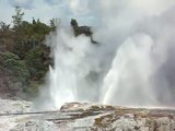
This road follows a line of lakes to the coastal town of Whakatane. This is a pleasant medium sized town on the estuary of the Rangitaiki River with a superb Ohope beach just a few km further east. But the main drawcard for our visit was the volcano on White Island, about 50 km off the coast.
|
The enticing advertised hoarding |

This is one of the few places in the world where you can walk around an active volcano in relative safety and I knew as soon as I saw a brochure that this was one trip not to be missed, and we weren't disappointed.
|
White Island volcano tantalises on the horizon |

You can visit by helicopter which is quite expensive ($NZ550) or take a day trip on a boat for 1/3rd the cost which, naturally, is what we did. Even cheaper is to view the crater activity from the rim on the Geonet webcam here.
|
Drawing ever closer to the volcano |

It takes 1 1/2 hours in the boat across open sea with quite a high cross swell so being a good sailor certainly helps. Janet failed in that respect, despite the Sealegs tablets, and one of the crew lent her an old shirt which made her look like a pirate. Janet may have been the first but she wasn't the only casualty.
|
Janet in her pirate shirt |

Landing on the barren island requires transfer to an inflatable Zodiac and is not easy. In fact half way out the Captain said he thought the swell might make it too difficult to land we might have to abort (but they would refund our money). He wallowed around for 1/2 an hour, which didn't help the seasickness, looking for dolphins and whales. We didn't find any but we did see some flying fish and then he said we could just make it in and made a rush for the sheltered bay.
|
The landing jetty on White Island, a broken down lump of 1800's concrete |

There is an old broken concrete jetty left behind by some previous sulphur miners from a failed industry in the 1800's. Landing required launching yourself from the wallowing Zodiac at some timber supports on the jetty and hauling yourself up. The return journey required the same dexterity, but we had to hurry, the tide was going out and the seas were rising again.
|
Getting ready to disembark |

On the island we had to wear hard hats in case of an ejection of lava bombs and carried gas masks in case the hydrogen sulphide gas became overwhelming. Due to the acidity of the ground, this volcano does not produce lava flows when erupting, like those on Hawaii do, instead it spits out hard lumps of lava which are still molten inside. We had 2 guides, a leader, John, who gave us a running commentary and a support guide Meghan, who trailed along to ensure no one got left behind.
| ||||||||||||||
Where we were heading, with some slight misgivings
Bubbling mud pools, well, bubbling. That's what they do.
It was an erie and slightly worrying feeling to be walking alongside hissing and roaring fumaroles, bubbling mud pools and sulphur beds, to the steaming, green, acidic crater lake, knowing that the last eruption was only 10 years ago. In fact, before the 2000 eruption, there was no lake at all and you could walk right across the crater. Not now though, and if we'd known the Christchurch earthquake was going to happen the very next day we'd have been even more concerned. Earthquakes have been known to trigger volcanic eruptions.
Fumaroles roaring continuously at 200ºC
Flash |


Trudging towards the crater
Flash
Flash
While watching the steaming crater lake, a cloud of sulphurous gas wafted over us (about 1.06 min into the video) and we had to don our gas masks and turn away until it passed by.
Whakatane to Corromandel |


The drive along the north coast and up the Corromandel Peninsular in one of the more scenic in the NI. The sheltered bays and beaches are a haven for boat owners, and nearly everyone in NZ seems to own one. The water on the north side was blue and inviting, although we didn't test its temperature, and on the southern side there is a range of dormant volcanoes. In between, huge paddocks of sweetcorn and Kiwi fruit are grown.
Corromandel to New Plymouth
New Plymouth to Wellington
Visiting Lesley
|
Lesley and Janet at the Byrd Memorial on Mount Victoria. "The South Pole is that way!". |

TBC...