


13 July
More shopping at IGA, had the usual gas bottle run-around but eventually Mitre 10 filled it, and filled up with diesel at Woolies.
Talked with Mark re money and the cat who had escaped.
Left after lunch east to towards Gascoyne Junction.
Camped at Rocky Pool, a nice rocky (obviously) section of an otherwise sandy river bank, with a huge pool of rocky water about 1/2 km across. A few other hardy travellers were also there since the rocks did not lend themselves to camping.

Rocky Pool

Our campsite at Rocky Pool
14 July
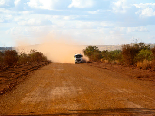
Scruffy scenery all along from Carnarvon has obviously been scarred by widespread flooding.
Gascoyne Junction has a pub, hotel and fuel outlet no more, it all got washed away in the big flood of 2010, after standing for more than 100 years (although the plaques outside withstood the flood's ravages OK and still promote the pub as THE place to be seen in Gas Jct, as if there were any others).
The flood must have been a km across and 50m deep to do that much damage. [Officially 12 inches of rain fell in 4 days, which was 60 times the monthly average and caused the river level to rise from a dry river bed to 8m above normal within 2 days].

The 100 year old Gascoyne Junction pub and service station used to be here, until the big flood washed them away...

...but the plaque survived.
Sir Charles Kingsford Smith, late of aviation fame, made his name in Gascoyne Jct and used to frequent this pub on his rounds as mail courier and transport carrier from Carnarvon to Meekathara, according to the surviving plaques.
New town buildings are being erected higher up from the river, I mean we don't want the shire offices or the public toilets to disappear in another spot of rain.
Had a look at Kennedy Ranges over the Gascoyne Jct river crossing but decided to try tracks new to us to the east instead.
Excellent drive east of Gas Jct, very interesting scenic drive through Glenburg and Dalgety Downs but a bit too long and we only just got to the Gascoyne River crossing before dark into a previous camping area Dave mentioned to us, one of the few places where we could pull off.
One reason we were behind schedule was the 1/2 hour stop to look for (and acquire) some fossils from the Pliocene era that are scattered along the roadside. I believe them to be fossils of gnathostomulid, but I could be wrong.

Gnathostomulid fossils? You be the judge.
15 July
The Gascoyne River crossing has an interesting flying fox for getting the mail through, a good piece of bush engineering for when the river was in flood in the pre-internet period.

A flying fox, circa 1910
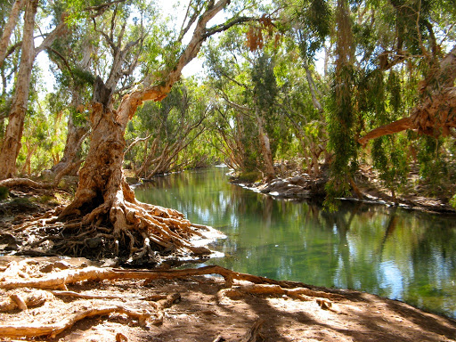
I spoke with a fellow on the HF radio today who had arrived at the same well on the Talawana Track that we had re-discovered 3 weeks ago (Midway Well). We had told him about it and where to find it in a previous radio hookup. He agreed it was a superb find and jettisoned all his existing water and refilled with Midway Well water since it was so good.
It's not often that you can drink water straight from under ground which tastes sweet and doesn't cause you immediate gastric problems, but this is one, and the only source of fresh water for 100km in any direction. There are many other similar wells we've come across in our travels but it's a good idea to filter or boil all under ground water anyway. Surface water should always be treated more respectfully since animals (and humans) will have access to it and may foul it.
Good smooth drive up to Mt Augustus and we stopped to look at some aboriginal carvings around a Gnamma rockhole, a place where rainfall collects in deep pockets and can provide a useful source of water long in to the dry season.
We did the 40km loop drive around the Mount and had lunch at a picnic spot at the base of the rock after a 3.5km surprisingly rough track in.

Mt Aug is a very impressive lump of rock, especially with a dark blue sky behind it, it's much larger than Uluru but covered in green bushes and trees. Claimed to be the largest single piece of rock in the world. There is a walking track up to the top (1106m) but fortunately we didn't find it.

Mt Augustus from afar

We found a dingo lazing on the track in the shade of a tree. As we passed by she got up and wandered lazily in a big circle and lay back down lazily under exactly the same tree after we had left. She lay with her front legs crossed, just like our Bella used to do. Bella had quite a number of dingo genes in her and the similarities become more obvious every time we see a dingo.

It's a bit distant but you can see she's crossed her legs in a very lady-like manner, just like Bella used to
The Dooley Downs track north from Mt Augustus is very scenic but quite rough, even though it's been recently graded, due to the large numbers of twists, turns, dips and creek crossings (all dry). Definitely not a caravan track.

Dooley Downs homestead, about 40 km north of Mt Augustus appears deserted and almost tumbledown, but seems to have all the modern facilities, a large new communications mast and a satellite dish next to an old windmill. But there appeared to be nothing happening there, maybe stations have merged and this outpost is no longer needed.

Camper Trailers and stuff falling off, twice.
Stopped to assist a camper trailer with a flat trailer tyre but they had already fixed it and were packing stuff away.
A couple of km further on another camper trailer (CT) came roaring around a corner towards us in a cloud of dust (CTs always make more dust than a 4wd, presumably due to the extra set of wheels to distribute the dust stirred up by the first 2).
Another couple of km further on, there were 3 lumps in the middle of the track so we stopped to remove them. They were 2 tents and a tarp, presumably from the aforementioned CT. I piled them on the roadside and tried calling in on UHF Ch 40 several times but no one answered. However, the CT which had the flat tyre then appeared and said it was their friends' (who had just passed us) stuff that they had come back for, it sounded logical so we carried on and they presumably picked up the stuff and turned around since they never came past us.

Stuff I piled up on the roadside
We did wonder why the 2 CTs would be heading in different directions if they were traveling together? Fact is stranger than fiction, and was to get stranger.
Yet another couple of km further on again and there were 2 more piles of stuff on the track, this time another tarp and a picnic chair which had shattered and distributed its aluminium legs all over the track. So I made another roadside pile and left them for someone else to come back for. If there had been any more stuff left on the track I was going to charge for my efforts and buy someone a rope.

Second pile of stuff.
We are camped on hillock near 9 Mile Pools on Pingandy Creek (no water) about 85 km NE of Mt Aug. where a grader has kindly left some tracks across the rocky terrain. As always, there will be a much better campsite just around the corner (but luckily there wasn't or for the next 50km).
16 July
Up at dawn for some photos. No wind and it was quite pleasant.

The surrounding scenery is very neat, comprising spinifex rings and small trees, all set is a landscape of bare rocks. Not good as a veggie patch though.

Completed the excellent Dooley Downs track. It was extremely scenic although a bit rough in parts.

The junction with the Ashburton Downs-Meekatharra road is one of those huge Y junctions about 1km across each side.
The A-M road scenery changes from red rocks and spinifex to white rocks and grassy tussocks. The coloured breakaway's are very reminiscent of the Coober Pedy area.
The Ashburton river covers a huge area when in flood and in 1997, the flood level was around 5 m above the road level, which is several km from the normal river bed. That would make the river more than 5km wide and probably hundreds of km long.
We've seen Wedgetails eagles today and several dingoes which were a bit thin and scrawny looking. At least they are not eating the 1080 poison baits (with added strychnine, according to the warning signs).
Plenty of dusty creek crossings and river plains and flat topped hills but the most striking were the Beasley Pinnacles which had pointed peaks.

Beasley's Pinnacles
We crossed the Tropic of Capricorn again just before Ashburton Downs Station but with no signs or fanfare.
Camping about 15 km short of the Nanutara-Wittenoom highway, 100km south of Tom Price
D called up and advised us about water and gas refills in Tom Price.
17 July
Good road for most of the way to Tom Price except for a 40km rough section which bypasses Paraburdoo.
Tom Price is a very green clean town that used to be a closed mining town that was opened up in the 80's. It has a good Coles supermarket, Coles express fuel outlet, free water and good facilities (except for the crappy expensive caravan park which fortunately we don't need).
The shopping was surprisingly friendly and cost effective and the service station gives 6¢ Coles discount even though there's only one supermarket in town and only one fuel outlet, so they don't need to.
We filled up the water and fuel tanks, and the pantry for the next stage of our trek across to Nullagine and up to Marble Bar. Could be a week or more between shops.
Sent Alan a happy birthday email which he wasn't supposed to open until tomorrow but he called right back. As I was talking to him I found a 5¢ piece on the ground and he said "Now you can afford to buy me a birthday present". I told him I wasn't intending to spend that much.
The scenery around Tom Price and the Pilbara area in general is quite spectacular with lots of quite high mountains and deep green valleys, although none have any water in them.

The Karajini National Park is close by too but we've been there a couple of times so we are giving it a miss this time.
You would hardly know that some of the world's biggest iron ore mines are in this area, although a huge ore train came past just as I went in to pay for fuel and 5 minutes later as I came out it was still going past. 30,000 tonnes of train (4 locomotives and over 200 ore trucks) is not something you want to get in the way of so it kind of makes sense to obey the crossing signals. Rio Tinto have 32 such trains working around the clock, one every 25 minutes.
From Rio Tinto's Site:
Each train is operated by a single driver, and comprises up to 234 ore cars, each ore car with a load capacity of approximately 112 tonnes. A fully loaded train weighs approximately 31,000 tonnes and is about 2.4 kilometres in length.
FYI, BHP run even longer trains and hold the world record for the longest ever train, 7.35km, 8 locomotives and 684 ore trucks, weighing in at 99,000 tonnes. It broke the couplings between trucks (what a surprise) but successfully made the 275km journey from Newman to Port Hedland in 2001.
The road north from Tom Price is visitor free but dusty gravel for much of the way.
Heavy mining trucks throw up a lot of dust...

...and then you hope no one is coming past them.
Camped at Rio Tinto Gorge, a not at all signposted camping area near, well, Rio Tinto Gorge. It has beautiful scenery, fresh air, a campfire, seclusion and internet service. What more could one ask? To be free? Well it is free, as well as being priceless.

Our priceless but free campsite at Rio Tinto Gorge
Had the double bonus of talking with Dave on the radio and emailing him at the same time.
18 July, Happy Birthday Alan
Drove through the Rio Tinto Gorge where vehicles have to call in on Ch 40 to ensure they don't meet head on. Very nice scenery but the road was very dusty, with several wide load mining trucks that we had to pull over for.

We passed by Wittenoom with all it's asbestos warning signs and we didn't venture far into the gorge. A pity because from photos, Wittenoom Gorge is extremely scenic, like most of the Pilbara hills. It's a shame that such a nice area has been forever tainted geographically and medically with the asbestos catastrophe.
The town has been abandoned but all the houses, shops, vehicles and gardens still remain, too dangerous or politically difficult to deal with.


You need respirators to venture further into Wittenoom Gorge

Would you buy a Hot Dog from this Wittenoom Deli?
At the end of the dusty road is Auski Roadhouse (now called Munjina). It's a large rambling outback service station cum caravan park with a huge forecourt, large enough for a triple road train to do a U turn in.
We needed nothing there since we filled up everything in Tom Price and are now traveling on the Woodstock-Marble Bar road.
We should however be travelling on the Hillside-Woodstock road but due to a minor error of navigation and the fact that someone had stolen the road signs, we are not.

Roadsigns like this make navigation difficult
No matter, it's very interesting and scenic anyway and we can get back on track from Rocky Island on the Shaw River to Hillside then thence down the planned Bonnie Downs track. We failed to find either the Motor Car Well or the Dead Bullock Well but we did find a number of dry waterholes and creek beds, and plenty of rocks.
Our abandoned tin mine campsite had to be abandoned since we failed to find the minuscule track leading to it. All roads apparently lead only to Marble Bar.

Maybe a little bit exposed but it was warm and still and no one could see us from the main track
We are camped instead on a small track about 1km from the main track in a open rocky clearing surrounded by a sea of spinifex. Fortunately it's warm and not windy and there's no one for miles. Neither is there a phone service.

But the sunset was pretty good...
19 July
A warm but cool night in our open campsite. Fans on for 1/2 the night and then doona's up around the ears for the other half.

...and the sunrise wasn't bad either.
Had a bran-free breakfast today to give my insides a break. I observed that unattended Weet-Bixes (Weet-Bii?) harden faster than QuickSet cement, but probably taste similar.
Started a competition to recall the worst ever cup of tea. Today's reconstituted tea leaves rated fairly well, but we still think that an earlier event whereby a fresh pot of tea was made without noticing that the pot still contained the previous day's half teapot of cold tea, probably leads the race.
J noticed that there weren't many birds around here. I suggested that there wasn't much for them to eat, but that I had spied some dingo footprints. Well what do dingoes eat then? Birds, obviously, otherwise there'd be some. You don't need a PhD in zoological sciences to travel the outback but it would probably help.

Our campsite at dawn
We completed the track to Rocky Island and in doing so, we successfully found 2 tracks which have now completely ceased to exist.
At Rocky Island we had to cross the Shaw River, one of the widest rivers we've seen, almost 1km across but almost totally water-free.

The Shaw River (a still from the forthcoming movie of the same name).
From there we headed south to Hillside, our original destination before the navigational error crept in, then down the Bonnie Downs track. In the 80km to the Nullagine-Marble Bar road, we saw not a single person, unlike the previous 150km when we saw at least 3 or 4 vehicles.
The Nullagine Road is another thing alltogether (or getheralltothing as my mate Charles is fond of saying).
Warning, Another Rant Follows: Dozens of CT's stirring up the dust as they pass and then pulling straight in front of us, unlike considerate mining vehicles, who stay on the RHS as long as possible as they come past, to reduce the dust we have to suffer. They also call up on the CB to announce their presence, whereas other vehicles just appear out of our dust in the mirror with no flashing of lights or soundings of horn to warn us.
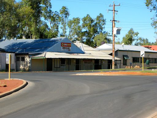
Had a look around Nullagine which took about 5 milliseconds, but they do have a pub, service station and general store, not to mention a mobile e service.

The "King's Cross" of Nullagine
Headed out east on the Skull Springs Road, a track dotted with former mine workings, mostly now extinct.

Skull Springs Road scenery
We're camped in a nice open clearing across a deep natural trench which I had to use 4wd to clamber in and out of, but which will deter all but the most ardent of campers.

Skull Springs campsite
So far all the aforementioned CT's have stuck to the Marble Bar Road as it's a short cut from Kalgoorlie north towards Broome, and school hols finish here this weekend so hopefully the pressure on resources will subside a bit.
And another thing, it's getting pretty hot up here, the sun is starting to sting and the evenings are warming up. Just though I'd mention that to those of a higher latitude.
We surprised a hoity-toity bustard along the way...

...and found the real Skull Springs.

Tomorrow Eel Pool and then Carawine Gorge.
20 July
The Skull Springs track was a lot slower than expected due to the frequent dips and gullies across the track. The signs says 105km of narrow and winding track but really it was rough and dippy rather than narrow and winding.

At Hay's Creek there's a sign saying road impassable to vehicles above 4 tonnes, but the track was being graded so that no longer applied but it was still rough and steep in parts.
We reached Eel Pool although maps variously call it Running Rivers Waterhole at the same location. Either way, there is only one 6km rough track in and we were expecting a full campsite but to our surprise it was empty. We chose the best site (obviously) shady but not too dusty. Later a string of 4wd's came in, drove a km or so down towards the water, which is an impassable track, and eventually returned all covered in muddy sh*t and left the area.
A mining 4wd followed the same pattern but came and went 3 times with different passengers each time. Then a large Hino truck and trailer arrived with him which looked like a road maintenance truck, but Darrien introduced himself and they were actually a roving musical group of 6 touring the north of the country doing concerts at Aboriginal communities.
They had presumably come down in the mining ute few at a time to look over the camping are before committing the big truck to the narrow track. He said they stayed at Carawine Gorge last night and there was almost no one there. He asked about the track to Nullagine since his truck is 8 tonnes and he was concerned about the size. No problems we said since his truck was 4wd and the difficult section of the track had been graded anyway.
21 July
Musical crew left early and we walked through the bush to Eel Pool for a swim. The water was superb, warm due to the thermal springs under the tree roots.
Took embarrassing videos of undignified entry into the pool (to be added, maybe).

Got a bit lost on the way back to the campsite so J insisted on following the wheel tracks instead of navigating by the sun. "But", I cried, "I am your leader and I shall follow you anywhere!" Luckily we'd left the GPS in the Oka for safe-keeping.
Left before lunch for Upper Carawine Gorge. The track started in very soft sand the then became stony and washed away, finally becoming very rocky leading to the river edge. Took us nearly an hour to do the 7km. We were still a couple of km from the gorge but we could get no closer without crossing the Oakover river which was quite deep and fast flowing.

The Oakover River at Upper Carawine Gorge (not shown because we never found it)
We camped on the river edge on a stony platform and did a 3km round trip walk along the banks. Quite scenic but nowhere far enough to reach the gorge. Bet it's no good anyway.

Campsite in the river bed at Upper Carawine Gorge
J did half the washing in clear river water but drew the line at bashing my shirts on a rock.

J doing the washing. Not very ergonomic so I got out the milk crate for her. It was the least I could do, really.
No one came past then or the next day although there were a couple of camper trailers and a tour party tent at a camping site about 2 km back up the track. No idea where they went, never saw or heard them.
22 July
Left for the real Carawine Gorge back along the same rough track. The 7 km took us only 40 minutes this time, since we already knew the hazards having come that way the day before.
The track to Carawine Gorge had been graded (for station mustering teams, not travellers) but was very corrugated. We took the right track this time and found and beautiful shaded riverside camping spot with green grass rather than deep dust or deep gravel. The track took us to a huge and very gravelly river bed opposite the gorge wall, but we've been there twice before and it was difficult to drive on, even in 4WD. This site is much better and there are plenty of birds to watch and unlimited clean water to do the washing in.

Met a couple of Kiwis from Wellington who were considering buying an Oka. They had apparently parked their LandCruiser next to us in Carnarvon for a sticky beak. We had a long chat about our trip around the Kiwi north island last year.
Plenty of birdlife on the river, storks, pelicans, black swans, ducks, moorhens, some species new to science, with a flypast of rainbow bee-eaters, kites and magpies above, plus some reed warbler thingies.
J completed the washing in even clearer river water and it was all dry by tea time.
23 July
Mustering helicopter took off at dawn, waking the whole neighbourhood, and returned at dusk. In between several burning off fires appeared over the hills. We assume the burn-off, happening directly after mustering, is either to deter cattle from returning or because the pilot had some left over phosphor bombs in his trousers pocket.

Walked up and down the creekside and noticed how much had change since 2007. Several huge floods plus a couple of cyclones had decimated the trees along the gravel beds and redistributed the sand and gravel. Also hundreds of small trees now line the creek edge so that access to the waterside for long sections is nearly impossible. A canoe is the best way to see the river and the gorge now.

However further up the creek where we were, new grassy camping areas have emerged with beautiful creekside views and a huge amount of birdlife. Plus ça change, plus s'est la même chose" as the French say which, literally translated, means "the more that things get buggered up the more that things remain same sh*t, different day".

Heron at work
Talked more with the Kiwis, about Oka's and how to find them (Robin and the Oka4wd.com website). Showed them how to get to Eel Pool on the map.
Had a campfire and burnt steak which seemed appropriate since several huge bullocks wandered up and down today. It is a cattle station after all.

Campsite at Carawine Gorge
24 July
Drove the 150km to Marble Bar (MB), seeing only around 5 or 6 huge 4 trailer road trains, to a very welcoming small town.
People are always surprised that MB is such a pleasant town in such a scenic setting, they expect a hot dusty outback town but it's not like that, at least not at this time of year. Sprinkled lawns, bitumen roads, scenic location and very few travellers make it a very pleasant town to visit.
"A Warm Welcome to Australia's Hottest Town" the sign says. All the facilities you could need with no pressure or "No Camping" signs, in fact no "No..." signs of any description.
MB is quite green and with a newly installed dump point, although people filling water containers from the tap intended for washing out portable loos was a bit off putting. We chose to fill with water at the Water Tank lookout, cleaner and a nice view as well.

The metropolis of Marble Bar from the water tower
We have officially reached Big Sky country where the blindingly bright blue/white sky stretches a full 360º or more in every direction. It's as if a hot blue semicircular bowl has been inverted over the earth to crete a huge artificial biosphere, which of course, it has.
They have a phone service in the MB biosphere so we checked the emails, none of note, and carried on to the Corunna Downs WW11 Airbase about 35km south of the town. We'd been here twice before and I even wrote an article on it that was published in The Wanderer magazine. The site is gradually fading into history as time and cattle take there toll but most of the WW11 supply dumps, aircraft revetments, taxiways, runways and all of the concrete building bases are still there. It's also in a very nice setting.

Google Earth photo of Corunna Downs airbase
One new item is a plaque to RAAF Sergeant Ernest Cook who operated the outdoor cinema for the troops stationed at Corunna Downs but who was tragically killed in a motor accident on the way to MB in Dec. 1944. The plaque was erected in 2010 by the WA 4WD association.

Camped on the concrete plinth of one of the buildings, possibly the admin hut, amongst the scattered detritus of war plus some more modern dumped junk.

Site of the hospital building
25 July
Walked down to Emu Creek which forms the southern boundary of the airbase and across the wide sandy creek bed. We turned left and trudged about 1/2 km to Bookargemoona Waterhole, which is almost dry at this time of year but which must have been a haven for the troops in the summer heat. Plenty of firetail finches about.

A siren next to be a would-be pool
Returning for lunch we heard voices from above. 4 young lads from Perth had climbed Ironstone Hill behind us and were surveying the scene. They had escaped from their wives for 2 weeks (and sent them to Bali as compensation) and were doing a whirlwind tour of the Pilbara. They didn't realise that we could hear every word the spoke from the top of the hill. They talked about Oka's (since one used to drive one for a tour company) and when they saw ours one exclaimed: "Just look at the size of that f**king antenna!" (I had my 9m antenna up).

Oka at the airbase with the "fooking" great antenna up
We wandered up to meet them and spent 1/2 hour chatting with them. They had come from Eel Pool and confirmed that the 2 Kiwis had made it OK. It's getting that we can almost remember every vehicle we have seen on this trek (sometimes several a day!) so I dread returning to a big city, like Port Augusta.
I climbed higher to take photos but J lagged behind, apparently favouring the company of 4 young men to being dragged up a mountain by me. Women, you just can't understand them.
Later we rediscovered the supply dumps we last saw in 2007 and pioneered new tracks never before attempted, before returning to our camping "plinth" for a campfire drink and watch the sunset.

Bomb spinners on a supply dump

Ammunition clips

The real thing. Fortunately this one's been fired.
The WA 4WD association has done a lot of research on Corunna Downs airbase and their information can been seen here (about 1/2 way down), here and an album of their photos here.
Had a long chat with Dave on the radio about our future plans. We'll go to Port Hedland again for supplies before confirming our direction.
26 July
Returned from Corunna Downs and visited the Comet Gold Mine Museum and the actual Marble Bar (made of jasper, an opaque reddish-brown variety of chalcedony (a microcrystalline type of quartz occurring in several different forms, including onyx, agate and jasper (an opaque reddish-brown variety of chalcedony )) etc. etc. Either way it's a very pretty form of rock made even more spectacular when highly polished or doused with river water, which is cheaper.

Us at the Marble Bar

A section of the bar, sploshed with water

Lunch was taken at Chinaman Pool a few meters away, presumably named from when Chinese people ran all the market gardens and used the river water for irrigation.
The Iron Clad Hotel in Marble Bar
I was checking our emails (nothing of note except some very funny Irish jokes from Dave who shall remain nameless) when Mark rang with the news that he had been offered a job. Not the one he was most keen on in but still an interesting IT service position. Congratulations all round. He even called back later to say he had discovered our cat, who escaped a week ago, safe and well and asleep as always, so a double bonus.
On the way back to town we met up with the 2 Kiwi's again after their trip to Eel Pool which they agreed was superb.
We then left the comfort of the MB biosphere and headed towards dusty Port Hedland and the shopping centre, or it's cornflakes for dinner tomorrow.
Camped tonight at Doolena Gorge, a huge gap made in George Range of hills by the Coongan River about 40km north of Marble Bar. A bit cool and windy.

Doolena Gorge

A pair of black swans with 4 swanlings on the Coongan River. Can you tell which is the ugly one?
Continue our trek here from Marble Bar to Derby via Broome.
Great photos and sounds like fun.
ReplyDelete