Welcome to David and Janet Ribbans blog

We live in Adelaide, South Australia and enjoy travel in the Australian outback in our Oka 4WD motorhome, hence the blog title.


To quickly locate any of our more than 80 travel and technical articles, use the drop down menus below or scroll down the lists in the right hand sidebar. But please read the disclaimer first, we've tried to be accurate and current but things can change...
You can also visit the official Oka 4WD website here.

Pandora Web Archive


We're now honoured to have our blogs archived
on the National Library of Australia's Pandora Web Archive.
Bookmark this link to the archived version in case anything ever goes wrong with Google, or I accidentally hit "Delete All" in a fit of pique. The drop down menus above might not work in the archived version but everything else should...

Monday, 27 October 2008

Tragedy in The Bungle Bungles


Although we didn't have the Oka at the time, we visited the Bungle Bungles (Purnululu) National Park for a second time in 2002.

One of the highlights of that visit was a half hour helicopter trip from Belburn Campsite over the rock formations. It was scary but exhilarating, since the chopper had no doors (to improve visibility!) and we were totally reliant on seat belts to keep us in place. But the views as we swooped amongst the valleys and peaks made for a wonderful experience.

So we felt particularly sad when we read recently that one of the helicopters had crashed just after taking off, killing the pilot and 3 young women passengers. (see http://www.smh.com.au/news/national/helicopter-smash-kills-four/2008/09/15/1221330747956.html).

Having been there and done that brings the tragedy into sharper focus for us. It might have been the very chopper we had ridden in. Either way it is a tragedy for the 4 people killed and their families, and for the reputation of one of the most memorable parts of Australia.

Tuesday, 21 October 2008

2008 Outback Trek

So we got back from our travels on a fine Sunday afternoon in late September. It was nice and sunny and things were green. We haven't seen that colour in South Australia for far too long, certainly not in our garden. However the reason for the greenery made itself readily apparent the next day, when it rained most of the day and was really quite cold, struggled to reach 15º in fact.

We didn't see rain (or many clouds) the whole 3 1/2 months we were away and we spent a lot of time in the warm tropics, so we're really feeling the cold too. I have a good tan and have lived in short shorts (to hell with my age!) for months, but everything is covered up now!

We went west first of all from Coober Pedy along the Anne Beadell Highway, terrible corrugations (real sports bra stuff!) visited the 1950's atomic bomb sites, very briefly I might add. It's a weird feeling being at ground zero and seeing lumps of molten glass all around you where the sand was heated to incredible temperatures.

IMG_8322.JPG-2008-10-21-15-21.jpg

The Anne Beadell, although fairly straight, is a very long track (nearly 1500 kms from Coober Pedy to Laverton), with almost no water and only one fuel supply stop, at Ilkurlka just 170 kms west of the state border WA and 700 kms from Coober Pedy.

The track is also very narrow and corugated for most of its length so breakdowns are common and should be anticipated. There are a few winding sanddune areas to add interest but it's no place for trailers and certainly shouldn't be tackled alone. Fortunately we were in the company of the Hallandal family with their Oka and Craig with his Patrol. This proved invaluable when the inevitable breakdowns occurred, which we all suffered to some degree.

IMG_8192.JPG-2008-10-21-15-21.jpg

I did say it was corrugated didn't I?

Water is available at 3 rest areas on the WA side of the border (assuming rain has replenished the tanks), but there is NO water available on the SA section.

There are a number of original Len Beadell markers along the track. This one is pretty remote, 1000 km (600 miles) from Coober Pedy, but still 400 km (250 miles) to go to Laverton.

IMG_8361.JPG-2008-10-21-15-21.jpg

We had one small puncture, near Dingo Claypan and a broken bolt on the bull bar. More seriously, some bolts came loose from the universal joint on the front drive shaft. This caused the drive shaft to flail around, damaging the transfer gear linkages, but fortunately nothing more critical and we soon had the shaft off the car, repaired using a spare UJ and back on the road again within an hour.

When we eventually reached Laverton, after about 11 days constant travelling due west, we headed down to Kalgoorlie and met up with an old friend at the Oka company there. After a week in Kalgoorlie, we then sort of turned around and headed back up the Great Central Road, eventually landing back in Alice Springs.

The chart below shows our speed along the Anne Beadell Highway. Around 25 kph for most of the first 900 kms after leaving Mabel Creek, but definitely slightly faster in the WA section, up to 50 kph plus in sections. Wow!

Picture4-2008-10-21-15-21.png

The dip in speed at 950 kms was when we visited the site of a Cessna aircraft which crashed in 1993 about 10 kms off the track. There were a lot of sanddunes to cross in that 10 kms.

IMG_8345.JPG-2008-10-21-15-21.jpg

IMG_8350.JPG-2008-10-21-15-21.jpg

From Kalgoorlie we spend a day exploring around Lake Ballard and then northeast up the Great Central Road, which is a wide gravel track and not all that inspiring, through Warburton to Giles where we had a tour of the Met Office.

IMG_8490.JPG-2008-10-21-15-21.jpg

This is not a photo of the fuel pumps at Warburton because it's not allowed.

From there we went up the Sandy Blight Junction road and across to Alice Springs. The Sandy Blight road was much more difficult than we were expecting. On the map it doesn't look very long, a tad over 200 kms, linking the Great Central Road near Giles to the Gary Junction Road which runs west from the Tanami Track just north of Alice Springs. However, while it is quite scenic, the track was much more difficult and, at nearly 400 kms, more protracted than we were expecting.

The first 70 kms or so of the track are quite rough but reasonable since it leads to an Aboriginal community at Tjurlka. Thereafter the road becomes a 2 wheel desert track which winds through hills and sanddune country for a further 300+ kms.

It is alternately very rocky and rough, or deep corrugated sand. It's the sort of track for which a sports bra is recommended! The 400 kms took us 3 days and I was quite looking forward to reaching the end, especially during the final 25 kms dead straight section which seemed to take forever.

We met up with Tim and Brenda Greenish and their Oka at Ormiston Gorge for a couple of days and then went up to Darwin via Litchfield National Park with Charles and Fred, some UK friends we met up with in Tennant Creek. After a week in Darwin, we drove across the Roper River Highway to Borroloola and then down the Savannah Way to Mount Isa via Doomagee.

IMG_9631.JPG-2008-10-21-15-21.jpg

This is National Highway #1 but it doesn't look at all like the Port Wakefield road up there.

It's a creek crossing-cum-road junction and there are several creek crossings like the one along this section of Highway #1.

The rest of the trip was very interesting but technically uneventful. We did have to replace the gas regulator in Katherine since it shat itself and we couldn't cook anything. And one of the collapsible chairs collapsed. But that was about all.

We did have an scary crocodile experience at the Mary River east of Darwin. We stumbled across one and it took off with frightening speed right in front of us. A bowel loosening experience!

MVI_92971CrocStills08-2008-10-21-15-21.jpgMVI_9297206-2008-10-21-15-21.jpg

This movie is not very good, but put yourself in our place as we came upon the croc on the side of the river. It was closer than it appears through the camera viewfinder and could have come our way...

Flash

Flash

Boulia, Bedourie and Birdsville

From Mount Isa, we turned south towards the 3 "B"'s, Boulia, Bedourie and Birdsville.

Boulia

IMG_9825.JPG-2008-10-21-15-21.jpg

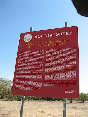
The level of detail on the Boulia Shire road signs was extraordinary, considering how little there actually is out here in outback Queensland.

IMG_9844.JPG-2008-10-21-15-21.jpg

You'll need an overnight stay to read that one.

We were very pleasantly surprised by Boulia and Bedourie. They are both very small, around 100 people, but very neat and well run. They also had excellent and very expensive amenities.

IMG_9835.JPG-2008-10-21-15-21.jpg

Min-MinEncounter2-2008-10-21-15-21.jpg

Boulia had a Min-Min Light Encounter show which took us through 6 or seven rooms filled with life-like animatronic figures giving us yarns and experiences by people who claim to have seen The Light, and the last and best room had a rotating stage which did a full 360 while dazzling us with a light show under a LED filled starry planetarium. It cost squillions to construct and one wonders why they spent so much in such a small town. It only cost $9 each and for another $1 we got a ticket to a marvellous museum thrown in.

Min-MinEncounter1_2-2008-10-21-15-21.jpg

This turned out to be another highlight. Not only the usual collection of olden day memorabilia and machinery, but also a world class fossil collection, with full fossil skeletons of prehistoric fish and carnivorous sea creatures excavated from the local area. The chap running the museum was also the person who found, dug up and prepared the fossils. He turned out to be a world expert in his field and had to protect his collection from big city museums which prey on these collections while their backs are turned. He did it by donating all his collection to the Queensland Museum, on condition that they could remain exactly where they were in Boulia. Smart or what?

So a very small town with 2 world class features. Great but you have to wonder why? They are never going to get huge numbers of tourists to this remote part of outback Queensland.

Bedourie

Now on to Bedourie which frankly, after Boulia, we didn't hold out much hope for. Especially when I asked the young girl in the "tourist office", which was a single desk in a corner of the small council office, "What are the things to see in Bedourie?" She said "Well, there's the mud hut next door, and an artesian bore which you need a key for, and a cemetery". I waited for the rest of the list but nothing more was forthcoming. So we did the mud hut in about 30 seconds, it was a former cattle station managers house built of mud brick walls during a long-ago boom in the cattle industry. We passed on the cemetery and sought out the artesian bore.

IMG_9851.JPG-2008-10-21-15-21.jpg

Well, what a surprise. Yes you needed a key, but some people already inside the wire let us in anyway. The bore was an ultra modern tiled spa pool, about 4m x 4m, filled with clear 40º water and a bikini-clad maiden from Canada trying to get a sun tan (Sharon or Sandra I think, it doesn't really matter) plus an electric spa pump driving 8 or 10 high pressure nozzles to give your back and legs a good work out. After a few minutes it got a bit hot so we walked across a large smooth green grassy patch to another surprise. A beautiful, full size 25m 6 lane swimming pool. It wasn't heated but that didn't matter it was a hot day anyway. But the biggest surprise of all was that it was all free, even to the local populace. The key was only to stop small children getting in unsupervised. See their site here.

IMG_9850.JPG-2008-10-21-15-21.jpg

THE free swimming pool and hot spa at the end of the path at Bedourie.

But it didn't stop there. Across from the council offices was a huge round shaped building called the Bedourie Community Centre. The Bedourie races were coming up the next weekend and council workers were busily preparing for an influx of race-goers to the Saturday night entertainment event. The hall would have held hundreds of people and was a smaller version of the Adelaide Entertainment Centre. This building and the aquatic centre would also have cost squillions and also in a very small rural town.

And so on to the next location.

Birdsville

IMG_9870.JPG-2008-10-21-15-21.jpg

Were we to get yet another surprise when we reached Birdsville? No we were not. Birdsville does not have the attractions of the 2 towns up the track, even though all 3 are in outback Queensland. It's a very dusty place with few things of note. The artesian bore spews out water at "over 100ºC" the sign says and it just runs away into the desert dust to form a boggy area. They've done nothing to turn it into a green, wildlife attracting wet lands.

The "famed" Birdsville Pub is nothing compared to the Daly Waters pub and in fact it's almost bare inside. We had the obligatory beer there of course, in fact we were propping up the pub all by ourselves for much of the time.

IMG_9897.JPG-2008-10-21-15-21.jpg

We singlehandedly supported the Birdsville pub.:

When I said the pub was almost bare inside, I did find something of interest to the 60's motoring public. It was a poster on the wall of the Australian Morris Minor Appreciation Society with all their cars parked outside the pub. It cost me a $2 donation to the RFDS to present this picture to you.

IMG_9895.JPG-2008-10-21-15-21.jpg

Morris Minor Association at Birdsville.:

There was a very good and clean museum in Birdsville with a myriad of memorabilia, but even this couldn't raise dusty Birdsville to the level of Boulia and Bedourie.

IMG_9876.JPG-2008-10-21-15-21.jpg

Birdsville museum, stacked with memorabilia.

The famed Birdsville Track was pretty straight forward, 300kms of rough gravel and rocks but nothing difficult.

IMG_9921.JPG-2008-10-21-15-21.jpg

Being hot and sunny made for some interesting optical effects.

Was this a mirage or water over the road?

We did experience a severe dust storm one hot night near Mungaranie Roadhouse which meant keeping all the doors and windows tightly closed and made it very stuffy.

Nearby was an artisian bore gushing boiling water into the desert, which is why nothing grows around the water course.

IMG_9914.JPG-2008-10-21-15-21.jpg

IMG_9910.JPG-2008-10-21-15-21.jpg

This informative but somewhat unnecessary sign was nearby.

Another interesting sign was this road sign covered in boots, shoes and thongs. Just how do people survive out here without footwear?

IMG_9865.JPG-2008-10-21-15-21.jpg

There was also an excellent campsite provided by the owners of Clayton Station near the Clayton Wetlands which was was very useful, and came with a free campsite dog, Max, to look after us.

We got back to Port Augusta a couple of days early so we went down to Cowell on the Eyre Peninsular for some R&R among the white sanddunes and found a large seal sunbathing on the beach.

And so back to cold wet Adelaide. It's very sad taking things out of the Oka at the end of a trip. I almost feel like apologising to it.

We might have a year off from long distance touring next year, Janet is keen to get the veggie patch into production again. What we might do is re-register the Oka again in the summer and do a few shorter trips, once I have worked through my 3 pages of To-Do items, that is.

We had no more problems with the Oka after leaving Manbulloo Station just outside Katherine (an excellent shady camping area in a working cattle station), where I changed the oil and did a full service, all systems have been working well, especially the new gas regulator.

Saturday, 11 October 2008

Big Ass Fan in Darwin

In Darwin, with it being so hot and all, they have installed very impressive fans in pubs and foyers of shopping malls to stir the air around. With 10 blades and about 4m in diameter they can shift a lot of air, or hair if you're too tall. They even have winged keels on the tips of the blades. They are called Big Ass Fans, made, appropriately enough by the Big Ass Fan Company.
Although I had never heard of them before, a visit to the Big Ass Fan website is an interesting diversion. The "Apple Computer" of fan design and manufacture, laid back but technically superb.

Monday, 25 August 2008

Raised Roof Development

We constructed a raised roof for the Oka, as an alternative to a poptop, which will give us sufficient head room to walk about and additional storage which is not available in a pop-top design.

OurOkaHi-Roof5-2008-08-25-16-20.jpg

An “artists” impression with a simulated raised roof on an old photo

Overall height was a concern on bush tracks, but the design height is no more than a bus model fitted with a roof rack and loaded with equipment.

The roof is built from a 25 mm square aluminium tube frame covered with aluminium sheeting. The over-cab section is more of an enclosed roof-rack for storage of lightweight, infrequently used items such as ropes, fanbelts, hoses, awning sides and walls, cold weather gear etc.

The main roof frame was built on a wooden space frame with the exact dimensions of the Oka roof line, which is easier than working 2 1/2m up in the air.

RoofConstruction3-2008-08-25-16-20.jpg

RoofFrameComplete-2008-08-25-16-20.jpg

The frame is substantially complete. Now for a test fitting.

RoofFrameFirstTest2001-2008-08-25-16-20.jpg

It seems to fit!!!

Looks pretty symmetrical too. The frame is surprisingly strong, but the leading edges and rear panels will be reinforced the to withstand the inevitable attack by tree branches.

InstalledRoofFramePics003-2008-08-25-16-20.jpg

With the nose cone assembled it was time for a final fitting of the frame before the lining and skin were fitted. The shape is partly for asthetics and partly as an attempt at improving aerodynamics.

CompletedRoofFramePics003-2008-08-25-16-20.jpg


RoofPano-2008-08-25-16-20.jpg

The roof was lined with 5mm CoreFlute, a sort of corrugated plastic sheeting normally used for sign boards, with edges fixed using plastic wall framing mouldings and double sided sticky tape to hold it in place during construction.

When complete the roof lining sheets are held in place between the plastic mouldings and the original Oka roof.

The CoreFlute was covered with FrontRunner headlining material (also called WonderWall, from Spotlight), stuck on with spray adhesive. Lighting, fans and vents were built in to the frame and wired up before the lining was installed. The exhaust grille for the fridge was also built into the side of the roof.

The frame was insulated with 25 mm GreenStuf polyester fibre to avoid the dangers of fibreglass or polystyrene. The outer aluminium skin was attached to the frame with Sikaflex 252 using all the recommended cleaning and priming instructions. The sheets overlap by 25mm from the rear to avoid leaks and were strapped on for 24 hours for the adhesive to cure.

Pictures24April095-2008-08-25-16-20.jpg

FrontSection004_edited-2008-08-25-16-20.jpg

The edge curves for the top sheets were made by bending them over a length of 150 mm PVC pipe clamped to the edge of a work bench before fitting.

The curved front side sections were first made using templates of brown paper to get the shape and size right before cutting the aluminium. It's surprising how different curved, angled sheets look when laid out flat.

The seams were sealed using Sikabond Pro and touched up with white paint.

Roofoutside006-2008-08-25-16-20.jpg

Completed roof assembly on its wooden spaceframe model, parked outside while the Oka was prepared to receive it.


CuttingouttheRoof011-2008-08-25-16-20.jpg

Liftingouttheroof025-2008-08-25-16-20.jpg

Cutting out the existing Oka roof proved to be quite easy with a jigsaw.

However, I was surprised how heavy the removed sheet of roofing steel was. The cut out is in from the edges by about 400mm so we can use the remaining roof area as the bottom of overhead cupboards.


Fittingtheroof2003-2008-08-25-16-20.jpg

Fittingtheroof2009-2008-08-25-16-20.jpg

Fitting the Roof. The was an exciting day when all the planning and construction work came together. After a couple of minor hiccups, the roof fitted on with no major dramas.

I made a frame to suspend the roof from the shed beams as it was lowered on to the Oka.

The roof is attached to the Oka using aluminium strips Sikaflexed to the roof and bolted to the Oka using the existing roof rack bolts. This maintains the sealed structure of the roof down the sides of the Oka to minimise leakage or dust ingress. A bead of polystyrene rope was inserted all round the lower edge of the roof to keep out draughts and insects.

Lifteingtheshedroof012-2008-08-25-16-20.jpg

Final fitting of the roof presented a challenge as the shed door is not tall enough to get the Oka out with the new roof on.

We needed another 300mm and some lateral thought was required. In the end we cut out the front of the shed roof and jacked it up so it looks a bit like a chinese temple. But we should now be able to drive in and out with about 200mm to spare.

Fittingtheroof2017-2008-08-25-16-20.jpg

External Views of Fitted roof. This is the roof after it's first fitting. It looks very similar to the planned design shown in the initial photos.

Insidetheroof001-2008-08-25-16-20.jpg

Insidetheroof002-2008-08-25-16-20.jpg

Internal Views of Roof. The inside of the roof looks quite swish and has plenty of headroom for us (1.85m). There will be plenty of storage space around the inside of the new roof.

LatestPics001-2008-08-25-16-20.jpg

FirstOutingtoShops003-2008-08-25-16-20.jpg

The completed roof on its first outing, showing the side plates which hold it down.

The internal fit out will be described in subsequent articles.

Wednesday, 26 March 2008

Bosch VE Injector Pump Resources

This is a list of internet resources for the Bosch VE Injector pump fitter to the Oka Perkins engine. They might prove useful to anyone who has an injector pump problem or is contemplating a DIY repair.

Note: These links DON'T relate directly to an Oka, but the VE pump is widely used on other diesel vehicles so the information is still relevant.
Oka manuals describe the pump and its removal in Section 3 of the Parts Manual and Section 12 of the Service Manual. However, there is no information in these manuals on repair or overhaul of the injector pump.
If any of this information is not accessible, I have downloads of all these sites on my computer.
A Bosch overhaul kit is available at around $120 which contains all the seals and minor overhaul parts but no information on how to do it.
I have replaced the throttle shaft seal in-situ (see this link) but I have not yet actually removed a pump.
Please advise if there are other resources I can add to this list.
Bosch book on the VE Pump (This is an original Bosch 64 page Technical Instruction Manual in pdf format.)
Parts Listing (This is a breakdown of the pump components. Click on an item under Pump. Parts to show photos and highlight the item on the diagram.)
VE Injector Pump Assembly in pictures (This is a a larger website with lots of photos. It takes a long time to load but is very informative.) 
Peugeot Diesel Pump upgrade Part 4 (This covers Boost Adjustments)
Peugeot Diesel Pump upgrade Part 5 (This covers Final Tuning of the Injection System)
Dodge 50 Perkins (This includes 10 pages from the Perkins Service manual) 
Priming the pump (A simple set of instructions)
Resealing a Bosch VE Injection Pump (A step by step approach to replacing the rear distributor head O-ring seal without dismantling the pump. However, it does require removal of the pump. I doubt that it's possible in-situ.)
Description of the Bosch VE Injector Pump (This is a very useful description of the pump operation. However, it's still a work-in-progress so not all the diagrams are yet present, but those that are there can be enlarged)
VE Pump Power Adjustments 1 and VE Pump Power Adjustments 2  (These sites show how to make some small power/fuel flow adjustments. Note the warning messages.)
Google Book Search on VE Pumps (This is a Google Books search. It returns many books relating to the Bosch VE injector pump, some of which can be reviewed on-line.)
Google Image Search on VE Pumps (This is a similar search but for images. They might well lead to more informative web sites.)

Friday, 21 March 2008

Our trek around Northern and Western Australia, May to Oct 2007

We returned safe and (mostly) sound from our 5 month trek around Northern and Western Australia. (Click on photos for a larger view, or go to http://picasaweb.google.com/dandjribbans to see all our photos).

We had a great trip, although it was exhausting and not without incident. 20,000 kms mostly on outback gravel and sandy tracks. No punctures but a broken rear spring bolt on the Mitchell Falls road, followed 3 months later by the same spring itself snapping like a biscuit (both main leaves). Different faults but the same end result, the rear axle slamming backwards on one side into the chassis and sending us crabwise. No dramas on lonely outback tracks though, but they did leave us on the side of the road for a day while we fixed them.

We also had some very scary moments when we realised we were all alone in the universe for days at a time, with only our HF radio for company. We have been to some of the remotest places and tracks in the country from which there is no hope of recovery in case of terminal breakdown, and even the Flying Doctor might be many hours or days away.

But overall the Oka performed remarkably well, it was economical, reliable (except for the few problems recorded herein, some of which were not entirely unexpected), fairly comfortable considering the track conditions, and none of the motorhome domestic systems that I had built seriously failed. There are always improvements that one can make of course based on experience, and many of these will be implemented over the summer, between treks.

2007%252BTrip%252Bon%252Bglobe-2008-03-21-18-30.jpg

This is our GPS track loaded into Google Earth.

We started gently enough with a leisurely drive up the Oodnadata track to Alice Springs where I had to fix a slow leak on one of our reserve fuel tanks.

From Alice we headed 1200 kms west across the Gary Junction Road (one of Len Beadell's outback tracks ) between the Great Sandy and Gibson deserts and through Aboriginal lands to intersect the Canning Stock Route (CSR) at Well 33 (the Kunawarritji Community, diesel at $2.80/l). Highlights of this section were the very pretty desert scenery and the stands of Desert Oak trees around Jupiter Well.

IMG_9271.JPG-2008-03-21-18-30.jpg

Me pumping water at Jupiter Well.

We then had a fabulous 300 kms trip down the centre section of the CSR crossing 200 sanddunes to Georgia Bore (near Well 22) and then headed 200 kms west again into the Rudall River National Park, the 2nd largest and remotest NP in the country (and the loneliest, we were the only people there).

From there we headed a further 300 kms to Newman for much needed supplies and retail therapy, and a taste of bitumen for a while.

An easy but long drive then took us west to Exmouth and Ningaloo Reef where we had a Whale Shark Tour and I swam with 3 huge (6 m) whale sharks. I thought I would be scared ****less but I found they were so gentle and placid that it was not scary at all. I have photos I took underwater and a DVD taken by one of the crew to prove it. Even saw 2 humpback whales pass in front of me while snorkelling. Janet stayed on the boat and took photos.

Photo23_3A-2008-03-21-18-30.jpg

I actually took this picture, a 6 m whale shark only 3 m away from me, and looking at me!

We spent nearly 2 weeks around Ningaloo Reef. It's so scenic it's difficult to leave but eventually we dragged ourselves through Marble Bar where we visited a WW11 secret airbase (never found by the Japanese, but we found it), which still has a fascinating array of runways and wartime supply dumps to fossick through.

We did Broome again, mostly for supplies, then up to Cape Leveque, Derby and on to the Gibb River Road. We've done this track twice before but it still has plenty of superb gorges to walk and swim in. Half way along the track we turned north to the Mitchell Plateau where we hadn't been before, and this is where the real fun started.

IMG_1632.JPG-2008-03-21-18-30.jpg

Janet at the Manning George Falls.

IMG_1889.JPG-2008-03-21-18-30.jpg

The magnificent Mitchell Falls.

IMG_1908.JPG-2008-03-21-18-30.jpg

Janet at the Mitchell Falls.

The track to Drysdale River Station is good and they have a really good camping area. From Drysdale it's a 400 kms round trip to the Mitchell Falls which are truly magnificent. Along the way there is an excellent camp on the rocky banks of the King Edward River with plenty of Aboriginal art including Bradshaw paintings. Getting there however is another story.

The Mitchell Falls road is wide but horribly corrugated and immediately leapt to No. 1 position on our "Worst Roads In The Country" list. 10-15 km/h is the best you can achieve without breaking something vital over the shattering corrugations, even with almost flat tyres. In fact we broke several things, including the rear wheel carrier mounting bracket which was fixed by (and still is held on with) rope. About 20kms out from Drysdale on the return leg, nearly out of gas, water, fuel and food (wouldn't you know it?), the main shackle bolt on the rear spring broke, leaving us stranded on the side of the road for 25 hours (Janet timed us) while we fixed it. It was hot and very heavy work jacking up the Oka and levering the axle back into position so we could replace the bolt. But we did it!

IMG_1987.JPG-2008-03-21-18-30.jpg

It's not supposed to be like this! This is also the spring which broke 3 months later.

While we were doing that, I noticed that the brake caliper had lost it's retaining spring and was imminently about to fall off. Being fully self sufficient and resourceful, I selected the correct size of tent peg (10mm) and tapped it into the caliper in place of the spring and bent the end over where it worked fine and is still there 5,000 kms later. (Or it would be if I hadn't had to remove it to replace a leaking oil seal in Katherine. Luckily I had 2 tent pegs).

We had a nice dinner out at the Drysdale Station restaurant to celebrate our achievement and our 35th wedding anniversary. We ordered steak but sadly they told us they had run out of steak (and this on one of the largest cattle stations in the country??)

Anyway nothing could dull our sense of achievement at having done a major repair on the side of the one of the remotest tracks in the country. As luck would have it, this experience was to come in handy 3 months later when the spring itself broke on the Mereenie Loop Road north of Kings Canyon.

However to regress, we completed the Gibb River Road to Wyndham, then to Kununnurra and back to the bitumen for the drive across the Victoria Highway through Katherine, Litchfield NP to Darwin.

IMG_2126.JPG-2008-03-21-18-30.jpg

We met Greg and Marie Boyle and their family and Oka in Wyndham

We spent a couple of weeks in and around Darwin which is a delightful place but ultimately it got too hot and humid for us and we retreated south supposedly to escape from it all. We were wrong, we escaped the humidity but not the heat.

Returning south we had the choice of 3000 kms of easy but boring bitumen to Adelaide or do some more outback travelling. So naturally we chose the latter.

We returned to Katherine the back way via Litchfield NP again and spent a few days there doing a full maintenance job on the Oka. Where we were going we would certainly need it.

From Katherine we headed down the Buntine Highway to Halls Creek where it was 38º, but they had a swimming pool. We had to stay for the weekend, waiting for the Telecentre to open to pay some bills, then headed down the Tanami Track to Wolfe Creek meteorite crater. This was our 3rd visit but it's always interesting. Just south of there we turned down the northern end of the Canning Stock Route at Billiluna and started a 700 km trek across the Great Sandy Desert back to where we first met the CSR at Well 33.

The 700 kms took 7 days and we crossed 620 big sand dunes averaging 15km/h and getting stuck on several (we have the videos). We met only 5 other vehicles in 7 days but it was the most exhilarating drive imaginable, if (and it's a big IF) you are fully prepared and totally self-sufficient. It was also very hot every day (38-40º) and we drank 5-6 litres of water a day each, even with the A/C on full.

Here's some videos of our trip on the CSR:

There are 51 wells on the CSR but only a handful have useable water in them (which you have to winch out manually, 19th century style). Most of the others are in ruins since they haven't been used for their original purpose for 50 years. We came across a burnt out a modern Ford Explorer 4WD (which is marked on the maps near Well 49), a poignant reminder of the risks associated with being in this area. Apparently they pulled over onto some spinifex with a hot engine which ignited the spinifex and that was that.

IMG_0599.JPG-2008-03-21-18-30.jpg

Their fridge and jerry cans are still there, all exploded in the heat.

It was at that point that we realised that there was only one way our Oka was going to get off this track and that was under its own steam. No vehicle recovery is possible from here. (Note: always take tent pegs and fencing wire, they are very useful).

IMG_0704.JPG-2008-03-21-18-30.jpg

In a mess of sand dunes and tracks a moving map is essential. The blue range rings around our position are 1 km apart, and so are the sand dunes.

Our other vital piece of equipment is a GPS and moving map computer display. Without these we would have been seriously worried many times about our exact location and direction. Signs in the outback are either non-existent or very basic and tracks can be very confusing. We relied on it many times when tracks disappeared or more often there were multiple options.

IMG_0741.JPG-2008-03-21-18-30.jpg

Typical outback sign, if you can spot it.

At Well 41 we had a lay-day because it was Grand Final Day. There are no radio stations in the Great Sandy Desert so I rigged up a long wire aerial over a tree (first I had to find a tree, not common in deserts) and just managed to drag in a faint ABC signal through the noise. So we sat in the shade and listened in. Technologically successful but unfortunately not the right outcome. By half time I had lost heart and spent the rest of the match fixing the fridge door which couldn't stand the vibration and had fallen off with a broken hinge. Superglue to the rescue, braced by an aluminium bracket.

Well we made it back to Well 33 OK and refilled with 160 L of fuel (at $2.80/L for diesel, unleaded petrol was $3.20/L). The sanddunes had nearly doubled our fuel consumption (down from 7 to 4 km/l), one of the other significant risks of being out there. We've never spent over $400 on fuel in one go before, but luckily they have Eftpos facilities at the Kunawarritji store. We were delighted to pay $2.80 a litre for diesel since fuel is rare out here and more important than water. With fuel you can go and find water. The opposite isn't true.

For the record, we carried 280 L of fuel, enough for 1200-1800 kms range depending on terrain, although we never got below 80 L in hand, enough for at least 400 kms in an emergency, 200 L of water (about 5-6 days worth with a daily frugal shower) and gas and food for at least 2 weeks. 

We crossed our previous track from Alice Springs at Well 33 (good water from the tank and windmill there) and headed down the Gary Highway (another one of Len Beadell's outback tracks). This is a dead straight but very corrugated 400 km track across the Gibson Desert. It ends at Everard Junction on the Gunbarrel Highway where we turned east and headed another 400 km to Warburton Community.

Just 16 km off the top end of the Gary Highway is Veevers Meteorite Crater. It's 80 m across and 15 m deep but we'd never heard of it until I researched our proposed route. The visitors book there still contains the original hand written notes by the fellow who identified it in 1975. Only a handful of people have ever been there.

At McPhersons Pillar, along a 30 km track east from the Gary Highway, we were at our remotest and loneliest point ever. The nearest help would have been at Warburton, 300 kms to the SE as the emu flies. In the 5 days and nearly 800 kms between Kunawarritji and the Grand Central Road junction we had seen not one single vehicle or person. Not a good place for an emergency. There were plenty of camels, dingoes and spinifex hopping mice though.

The Gunbarrel Highway is badly washed away and quite dangerous in places. In fact the eastern section has been closed totally. The route now takes you down the Heather Highway (known as the Horrible Highway for corrugated reasons) to the Great Central Road (sounds grand but is just a wide corrugated gravel track).

IMG_1059.JPG-2008-03-21-18-30.jpg

The Gunbarrel passes a pleasant range of hills called the "Schwerin Mural Crescent", named by Ernest Giles after the Princess of Schwerin.

No, we had never heard of it either, or the Princess of Schwerin. (Wikipedia says: Schwerin is a city in northern Germany and the capital of the state Mecklenburg-Vorpommern). So now we all know.

IMG_1074.JPG-2008-03-21-18-30.jpg

From Warburton we headed along the Great Central Road to Giles Met Station, established by Len Beadell in 1955 to provide meteorology info for weapons testing at Woomera. We wanted to do a tour of the station but they had "computer problems" so it was cancelled. We did see the launching of the daily weather balloon though, which they still use for acquiring upper atmosphere data used by commercial aircraft.

We thought we were nearly home but no. From Giles it's a further 300 kms via Docker River to Uluru and civilisation at Yulara, and our first bitumen since Halls Creek 2000 kms to the north.The last part of the track to Yulara was very unpleasant, 40º and blowing a hot gale from the west. Our own dust was overtaking us and the engine was overheating since there was no air blowing though the radiator. At Yulara there was a sand storm and even worse, the swimming pool was closed for maintenance. Luckily they had made arrangements for campers to use the pool at one of the resort hotels for free.

So with renewed enthusiasm we left Yulara (still 450 kms from Alice Springs mind you) and headed to Kings Canyon. It was stinking hot again so we only did the short canyon walk since we had done the superb rim walk twice before anyway.

From there we headed around the gravel Mereenie Loop Road to Alice Springs. This road had worsened considerably since our previous trip and within 30 kms the rear spring broke both its main leaves. Snapped just like a biscuit. Presumably the previous 2000 kms of corrugations had weakened it and a few kms of smooth bitumen had finished it off. Now I knew where the creaking noises had come from.

IMG_1156.JPG-2008-03-21-18-30.jpg

Not much holding up the Oka, just the edge of the broken spring.

Anyway by now we were fully experienced in fixing such things and we had the axle strapped to the chassis in a couple of hours and were on our way again, but ever so slowly, as we crawled 260 kms into Alice Springs (fortunate name). It took us 3 days and we used our HF radio to call for some assistance. The radio base operator made some phone calls for us and by the time we arrived in Alice, a spring repair company was expecting us and fortuitously had managed to find a second hand spring for an Oka. They fitted it on a Saturday morning and we were on our way within 24 hours. The value of our HF radio has proved itself. We have heard dozens of other emergency calls before but this was the first time we had made one ourselves, although we were never in any real risk of getting stranded. If it had happened a few weeks earlier the outcome would have been different but we would still have fixed it and got mobile again.

The journey back to Adelaide was uneventful but just to push our luck a bit further, we diverted across the Painted Desert to Oodnadatta and then down the Oodnadatta Track to the Flinders Ranges and back home. We arrived 15 minutes late, but after 5 months way we didn't think that was too bad?

This is just a snapshot of our adventures, plenty more things happened that we still have to tell. We had a GREAT trip and after a rest we'd love to do it all again.

The Final Analysis

20,000 kms, 5000 photos, 3000 L of fuel, 120 different campsites, 8 major outback tracks, 4 other Oka's seen, 3 deserts crossed, 2 birthdays, one spring broken, no punctures, cheaper than living at home. Not a bad equation.